1990s Maps of Oak Grove, Middle Smithfield Township
Explore 2 historic maps of Oak Grove from the 1990s. These maps offer a rare glimpse into what life looked like during the 1990s — showing old roads, neighborhoods, homes, and landmarks that have changed or disappeared over time.
Whether you're researching your family's past, planning a metal detecting trip, or studying how Oak Grove's landscape evolved across the 1990s, these high-resolution maps are a powerful tool for exploring the history of this region.
- Focus on a specific era: All maps on this page are from the 1990s, giving you a focused view of this time period.
- See what’s changed: Compare century-old streets, trails, and buildings to today's modern landscape using overlays and satellite layers.
- Research with precision: Use these maps for genealogy, historical research, land use analysis, or educational projects.
- View, download, or print: Maps are fully viewable online in high resolution, and can be downloaded or printed for your own records.
Start exploring Oak Grove's history through authentic maps from the 1990s. This is your window into the past.
Oak Grove, Middle Smithfield Township maps
(2)- 1993 Map of Bushkill
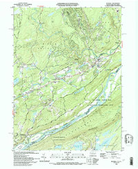 1993 Bushkill1993 Print · USGSThe Delaware River valley in the early nineties reveals a landscape of protected recreation and rural mountain life. Genealogists and hikers can trace the Appalachian Trail across Kittatinny Mountain or find old community centers like St Johns Ch and Middle Smithfield Sch.
 - 1999 Map of Bushkill, 2002 Print
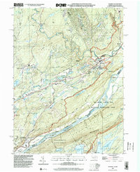 1999 Bushkill2002 Print · USGSMonroe County and the New Jersey borderland appear here at the close of the century, centered on the recreational corridor of the Delaware River. Genealogists and hikers can trace the Appalachian Trail past Sunfish Pond or locate family sites at Oak Grove and St Johns Ch.
End of results
Showing maps 1-2 of 2
Frequently asked questions
- What are the different types of historical maps available for Oak Grove?
- What is the oldest map of Oak Grove?
- Where can I purchase historical maps of Oak Grove for my home or office?
- Where can I download high-res historical maps of Oak Grove?
- Are there historical topographic maps available for Oak Grove?
- Is there historical aerial imagery available for Oak Grove?
- Where are historical maps of Oak Grove sourced from?