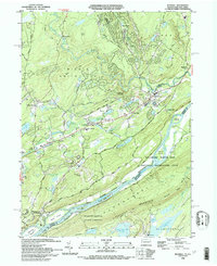
1993 Map of Bushkill
USGS Topo · Published 1993About this map
The Delaware River carves a dramatic path through this 1993 study, separating Pennsylvania and New Jersey while defining the Delaware Water Gap National Recreation Area. The landscape is dominated by the steep slopes of Kittatinny Mountain and the watercourse itself, which features several major landforms like Poxono Island, Depue Island, and Tocks Island. Along the western banks, the community of Bushkill and the hamlet of Shoemakers sit near the confluence of Bushkill Creek, a waterway notable for its significant drops at Bushkill Falls and Resica Falls.
Find a feature on this map
71 named features on this map. Tap any name to fly to it.
Don’t see what you’re looking for? This feature index may not catch every label — zoom into the map to look around manually.
Map Details
Editions of this 1993 Bushkill Map
This is the sole edition of this map. No revisions or reprints were ever made.
Other maps of this area

1888 · Hackettstown
USGS Topo · 1:62,500

1891 · Wallpack
USGS Topo · 1:62,500

1891 · Delaware Water Gap
USGS Topo · 1:62,500

1893 · Delaware Water Gap
USGS Topo · 1:62,500

1893 · Wallpack
USGS Topo · 1:62,500

1894 · Hackettstown
USGS Topo · 1:62,500

1898 · Hackettstown
USGS Topo · 1:62,500

1900 · Raritan
USGS Topo · 1:125,000

1905 · Raritan
USGS Topo · 1:125,000

1905 · Hackettstown
USGS Topo · 1:62,500
Featured Places
- Blairstown, NJ
- Hardwick Township, NJ
- Lehman Township, PA
- Saw Creek, Lehman Township
- Middle Smithfield Township, PA