1990s Maps of Smithfield Township, Pennsylvania
Explore 8 historic maps of Smithfield Township from the 1990s. These maps offer a rare glimpse into what life looked like during the 1990s — showing old roads, neighborhoods, homes, and landmarks that have changed or disappeared over time.
Whether you're researching your family's past, planning a metal detecting trip, or studying how Smithfield Township's landscape evolved across the 1990s, these high-resolution maps are a powerful tool for exploring the history of this region.
- Focus on a specific era: All maps on this page are from the 1990s, giving you a focused view of this time period.
- See what’s changed: Compare century-old streets, trails, and buildings to today's modern landscape using overlays and satellite layers.
- Research with precision: Use these maps for genealogy, historical research, land use analysis, or educational projects.
- View, download, or print: Maps are fully viewable online in high resolution, and can be downloaded or printed for your own records.
Start exploring Smithfield Township's history through authentic maps from the 1990s. This is your window into the past.
Smithfield Township, PA maps
(8)- 1992 Map of Portland, 1995 Print
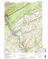 1992 Portland1995 Print · USGSThe Delaware River gorge and Kittatinny ridgeline define this borderland during the late twentieth century. Researchers can trace the legacy of river industry and transport through the Old Railroad Grade, old rural burials at Fairview Cem, and the quiet Vail Sch.
 - 1992 Map of Stroudsburg, 1995 Print
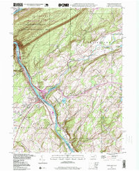
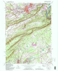 1992 Stroudsburg1995 Print · USGSStroudsburg and the Delaware Water Gap are shown in the early nineties, capturing the intersection of growing Pocono boroughs and protected parklands. Genealogists can locate family sites at Stroudsburg Cem or trace the routes of the Appalachian Trail through Cherry Valley.
 - 1993 Map of East Stroudsburg
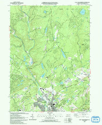 1993 East Stroudsburg1993 Print · USGSThe Pennsylvania Poconos in the early nineties show a landscape of growing mountain communities and secluded lakes. Genealogists can trace family names at Mt Zion Ch or explore the streets of East Stroudsburg and the settlement at Analomink.
 - 1993 Map of Bushkill
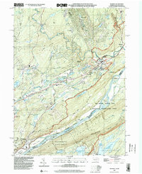
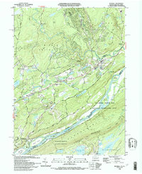 1993 Bushkill1993 Print · USGSThe Delaware River valley in the early nineties reveals a landscape of protected recreation and rural mountain life. Genealogists and hikers can trace the Appalachian Trail across Kittatinny Mountain or find old community centers like St Johns Ch and Middle Smithfield Sch.
 - 1997 Map of Portland, 1999 Print
 1997 Portland1999 Print · USGSThe Delaware Water Gap region at the close of the twentieth century shows a landscape defined by its river-and-rail corridor. Genealogists and historians can trace local roots at James Ch, St Vincent Cem, or the old riverside village of Portland.
 - 1999 Map of Stroudsburg, 2001 Print
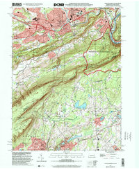 1999 Stroudsburg2001 Print · USGSThe Delaware Water Gap and the twin boroughs of the Poconos are seen here as they entered the twenty-first century. Genealogists and local historians can trace the many parishes and cemeteries of the slate belt, including St Pauls Ch and Mt Carmel Cem.
 - 1999 Map of East Stroudsburg, 2002 Print
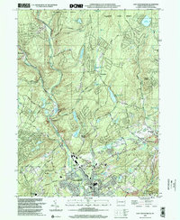 1999 East Stroudsburg2002 Print · USGSThe Pocono foothills come alive in the late nineties, showing a landscape defined by the winding Brodhead Creek and the Erie Lackawanna RR. Trace local history through landmarks like Mt Zion Ch, the Gravel Pit, and the Alpine Mtn Ski Area.
 - 1999 Map of Bushkill, 2002 Print
 1999 Bushkill2002 Print · USGSMonroe County and the New Jersey borderland appear here at the close of the century, centered on the recreational corridor of the Delaware River. Genealogists and hikers can trace the Appalachian Trail past Sunfish Pond or locate family sites at Oak Grove and St Johns Ch.
End of results
Showing maps 1-8 of 8
Top cities near Smithfield Township
- East Stroudsburg historical maps
- Delaware historical maps
- Blairstown historical maps
- Stroudsburg historical maps
- Bangor historical maps
- Stillwater Township historical maps
See more
Top neighborhoods of Smithfield Township
- Marshalls Creek historical maps
- Minisink Hills historical maps
- Twin Falls historical maps
- Shawnee on Delaware historical maps
- North Water Gap historical maps
- Craigs Meadow historical maps
Frequently asked questions
- What are the different types of historical maps available for Smithfield Township?
- What is the oldest map of Smithfield Township?
- Where can I purchase historical maps of Smithfield Township for my home or office?
- Where can I download high-res historical maps of Smithfield Township?
- Are there historical topographic maps available for Smithfield Township?
- Is there historical aerial imagery available for Smithfield Township?
- Where are historical maps of Smithfield Township sourced from?