Old Maps of Shawnee on Delaware, Smithfield Township for Academic Research
Study the evolution of Shawnee on Delaware with 19 high-resolution historic maps. Whether you're teaching, researching, or modeling changes in land use, these maps provide essential visual documentation of urban, environmental, and geographic change.
- Analyze long-term change: Track patterns in development, transportation, and natural features.
- Ideal for environmental or urban studies: Support academic projects with primary historical map data.
- Use in the classroom or lab: Educators and researchers rely on these maps to bring historical context to life.
These maps are a powerful tool for teaching, research, and visualizing how Shawnee on Delaware has changed over the decades.
Shawnee on Delaware, Smithfield Township maps
(19)- 1924 Map of Bushkill
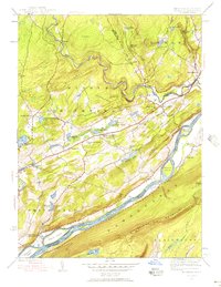
 1924 Bushkill1924 Print · USGSThe Pennsylvania and New Jersey borderlands come to life in the mid-twenties, showing a landscape of small school districts and traditional river crossings. Researchers can locate family landmarks like Marshall Falls, trace the Delaware Lackawanna and Western rail line, and find old sites like Smoky Hill School.
 - 1943 Map of Bushkill
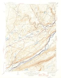
 1943 Bushkill1943 Print · USGSMonroe County and the Delaware River valley are captured in the early 1940s during a time of rural persistence and local industry. Genealogists and historians can locate family landmarks like Dimicks Ferry, St Thomas Chapel, and the vanished sites of Craig Meadows.2 unique versions available
 - 1944 Map of Bushkill, 1956 Print
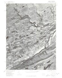
 1944 Bushkill1956 Print · USGSThe Delaware Water Gap region is seen here during the mid-1940s, just as the mountain landscape was becoming a premier recreation destination. Genealogists and hikers can trace old river crossings like Dimicks Ferry and landmark sites such as Bushkill Falls and Sand Hill Ch Cem.7 unique versions available
 - 1947 Map of Bushkill
 1947 Bushkill1947 Print · USGSThe Delaware River valley in the mid-1940s reveals a landscape of river-crossing points and upland ridges before the major changes of the later century. Trace local family roots at Dimicks Ferry, Middle Smithfield Sch, or the small settlement of Shoemakers.2 unique versions available
 - 1950 Map of Scranton, 1952 Print
 1950 Scranton1952 Print · USGSMid-century Northeast Pennsylvania and the Hudson Valley come alive in this survey of the tri-state region. Genealogists and historians can trace the dense rail networks of the Erie RR and DL&W RR between industrial hubs like Scranton and Wilkes-Barre.
 - 1953 Map of Scranton
 1953 Scranton1953 Print · USGSNortheastern Pennsylvania and the Catskills are shown in great detail during the early fifties, a time when rail lines and river valleys dictated the region's growth. Genealogists and historians can trace the industrial hearts of Scranton and Wilkes-Barre or locate remote landmarks like High Point and Lake Wallenpaupack.
 - 1959 Map of Scranton
 1959 Scranton1959 Print · USGSThe northern coalfields and the Hudson Valley meet in this mid-century survey of the Pennsylvania and New York borderlands. Genealogists and historians can trace the intricate rail networks of the Erie Railroad and the vast waters of Lake Wallenpaupack.2 unique versions available
 - 1959 Map of Pocono
 1959 Pocono1959 Print · USGSThe Pocono Mountains region is captured here in the late fifties, showcasing its evolution from a railway-dependent timber and ice landscape to a premier resort destination. Researchers can locate dozens of country schoolhouses like Maplewood Sch and trace the paths of the Erie RR through Hawley and Kimbles.
 - 1962 Map of Scranton, 1977 Print
 1962 Scranton1977 Print · USGSThe industrial heart of eastern Pennsylvania and the New York Catskills are captured here in the early sixties. Genealogists and historians can trace the dense valley settlements from Scranton to Wilkes-Barre and the rail lines of the Erie Lackawanna Railroad.2 unique versions available
 - 1965 Map of Scranton
 1965 Scranton1965 Print · USGSThe tri-state highlands of Pennsylvania, New York, and New Jersey come alive in the mid-sixties as industry and recreation converge. Trace the intricate rail lines of the Erie Lackawanna RR or locate landmarks like the U S Military Academy.2 unique versions available
 - 1976 Map of Bushkill, 1978 Print
 1976 Bushkill1978 Print · USGSThe Delaware River valley in the mid-seventies shows a landscape defined by its waterways and small riverside settlements. Trace the local geography around Bushkill and Shoemakers, or examine the early footprint of the Yards Creek Reservoir.
 - 1986 Map of Scranton
 1986 Scranton1986 Print · USGSNortheastern Pennsylvania in the mid-eighties shows an era of transition between its deep-rooted mining history and modern transit growth. Researchers can trace the industrial footprint of a Strip Mine, locate the Tobyhanna Army Depot, or find family sites near St Marys Cem and Wilkes College.2 unique versions available
 - 1993 Map of Bushkill
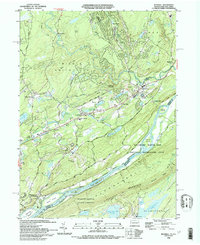 1993 Bushkill1993 Print · USGSThe Delaware River valley in the early nineties reveals a landscape of protected recreation and rural mountain life. Genealogists and hikers can trace the Appalachian Trail across Kittatinny Mountain or find old community centers like St Johns Ch and Middle Smithfield Sch.
 - 1999 Map of Bushkill, 2002 Print
 1999 Bushkill2002 Print · USGSMonroe County and the New Jersey borderland appear here at the close of the century, centered on the recreational corridor of the Delaware River. Genealogists and hikers can trace the Appalachian Trail past Sunfish Pond or locate family sites at Oak Grove and St Johns Ch.
 - 2011 Map of Bushkill, 2011 Print
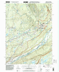
 2011 Bushkill2011 Print · USGSCovers Shawnee on Delaware, including Blairstown, Hardwick Township, and other nearby areas
 - 2013 Map of Bushkill, 2013 Print
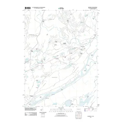
 2013 Bushkill2013 Print · USGSCovers Shawnee on Delaware, including Blairstown, Hardwick Township, and other nearby areas
 - 2016 Map of Bushkill, 2016 Print
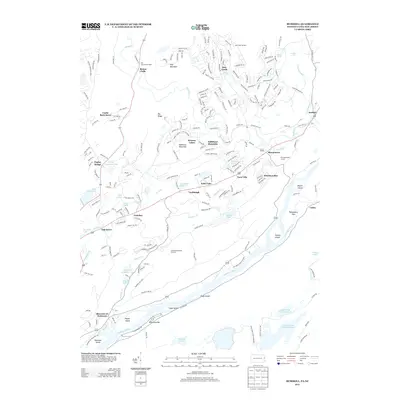
 2016 Bushkill2016 Print · USGSCovers Shawnee on Delaware, including Blairstown, Hardwick Township, and other nearby areas
 - 2019 Map of Bushkill, 2019 Print
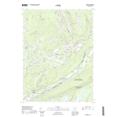 2019 Bushkill2019 Print · USGSCovers Shawnee on Delaware, including Blairstown, Hardwick Township, and other nearby areas
 - 2023 Map of Bushkill, 2023 Print
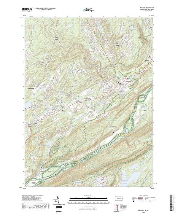 2023 Bushkill2023 Print · USGSThe Delaware River valley at the New Jersey border shows a landscape where conservation meets historic river settlements. Genealogists and hikers can trace the Appalachian Trail or locate family sites like the Sons of Israel Cem and Sand Hill Cem.
End of results
Showing maps 1-19 of 19
Top cities near Shawnee on Delaware
- East Stroudsburg historical maps
- Delaware historical maps
- Blairstown historical maps
- Stroudsburg historical maps
- Allamuchy Township historical maps
- Bangor historical maps
See more
Frequently asked questions
- What are the different types of historical maps available for Shawnee on Delaware?
- What is the oldest map of Shawnee on Delaware?
- Where can I purchase historical maps of Shawnee on Delaware for my home or office?
- Where can I download high-res historical maps of Shawnee on Delaware?
- Are there historical topographic maps available for Shawnee on Delaware?
- Is there historical aerial imagery available for Shawnee on Delaware?
- Where are historical maps of Shawnee on Delaware sourced from?