Old Maps of Arlington Heights, Stroud Township for Hiking & Exploration
Hike through history with 43 historic maps of Arlington Heights. Explore old trails, ghost towns, and forgotten backroads — perfect for outdoor adventurers and local explorers.
- Rediscover forgotten places: Map out old mining camps, roads, and footpaths that no longer exist on modern maps.
- Layer with modern tools: Combine with LiDAR or satellite views to plan hikes through historical terrain.
- Made for exploration: Popular among hikers, overlanders, and local history lovers.
Use these maps to find adventure and explore the hidden past of Arlington Heights.
Arlington Heights, Stroud Township maps
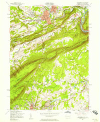
(43)- 1891 Map of Delaware Water Gap
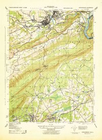
 1891 Delaware Water Gap1891 Print · USGSThe Delaware River corridor was a bustling industrial and transport hub in the late nineteenth century. Genealogists and historians can trace the region's slate mining roots at the Old Bangor Slate Quarry or locate historic river crossings like Myeres Ferry and Hartzells Ferry.
 - 1893 Map of Delaware Water Gap
 1893 Delaware Water Gap1893 Print · USGSThe Delaware River borderlands between Pennsylvania and New Jersey are captured here in the late nineteenth century as the slate industry and railroads transformed the valley. Researchers can locate the Old Bangor Slate Quarry, trace the river crossings at Myeres Ferry, and explore old stops like Stone Church P. O.12 unique versions available
 - 1924 Map of Bushkill
 1924 Bushkill1924 Print · USGSThe Pennsylvania and New Jersey borderlands come to life in the mid-twenties, showing a landscape of small school districts and traditional river crossings. Researchers can locate family landmarks like Marshall Falls, trace the Delaware Lackawanna and Western rail line, and find old sites like Smoky Hill School.
 - 1936 Map of Delaware Water Gap
 1936 Delaware Water Gap1936 Print · USGSThe Delaware River valley thrived in the mid-thirties as a critical junction for coal-hauling railroads and mountain tourism. Local historians can trace family roots through numerous rural landmarks like Spoke Factory Sch, Ross Cem, and Slateford Junction.4 unique versions available
 - 1941 Map of Delaware Water Gap
 1941 Delaware Water Gap1941 Print · USGSThe Delaware River valley is captured here in the early 1940s, showing the borderlands of Pennsylvania and New Jersey. Genealogists can trace family names through dozens of rural landmarks like Three Church Hill, Brass Castle, and the Stone Church PO.
 - 1942 Map of Delaware Water Gap
 1942 Delaware Water Gap1942 Print · USGSThe Delaware River gorge and its surrounding ridges come into focus during the early war years, highlighting a critical rail and river junction. Trace local history through family-named landmarks like Miller Ch, rural Quaker Plain Sch, and the unique name of Manunka Chunk.3 unique versions available
 - 1943 Map of Bushkill
 1943 Bushkill1943 Print · USGSMonroe County and the Delaware River valley are captured in the early 1940s during a time of rural persistence and local industry. Genealogists and historians can locate family landmarks like Dimicks Ferry, St Thomas Chapel, and the vanished sites of Craig Meadows.2 unique versions available
 - 1943 Map of Bethlehem
 1943 Bethlehem1943 Print · USGSNorthampton and Lehigh counties hummed with industry and river commerce during the early war years. Researchers can trace the path of the Lehigh Valley RR, locate family-named landmarks like Chief Tatamy, and find rural schools such as Mexico School and Poplar Valley Sch.
 - 1943 Map of Stroudsburg, 1944 Print
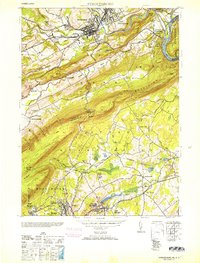
 1943 Stroudsburg1944 Print · USGSThe Poconos and the Delaware Water Gap are captured here during the wartime era, showing a mix of industrial centers and mountain terrain. Researchers can trace the rail lines serving Slate Quarries or find local landmarks like Temple Israel and Mammoth Hosiery Mills.
 - 1944 Map of East Stroudsburg, 1956 Print
 1944 East Stroudsburg1956 Print · USGSEast Stroudsburg and the surrounding Pocono townships are captured here in the mid-1940s, a landscape defined by the winding Brodhead Creek and the busy Delaware Lackawanna and Western rail line. Researchers can trace rural landmarks from Lesoine Sch to the Franklin Hill Cem and the early Pipher Airport.6 unique versions available
 - 1944 Map of Newark, 1971 Print
 1944 Newark1971 Print · USGSThe industrial corridor from Philadelphia to New York was in a period of massive transition during the mid-forties. Genealogists and researchers can trace the rail lines of the Lehigh Valley RR, locate military installations like Picatinny Arsenal, and explore the early sprawl near Levittown.5 unique versions available
 - 1947 Map of East Stroudsburg
 1947 East Stroudsburg1947 Print · USGSThe Pocono foothills around the time of the post-war boom reveal a network of mountain villages and valley creeks. Genealogists and local historians can locate rural landmarks like Beakleyville Ch, the Boise Sch, and the Pipher Airport.2 unique versions available
 - 1949 Map of Newark
 1949 Newark1949 Print · USGSThe industrial corridor between Philadelphia and New York comes alive in this post-war survey. Genealogists and historians can trace the massive rail networks of the Reading Railroad and locate major installations like Fort Dix or Picatinny Arsenal.2 unique versions available
 - 1950 Map of Scranton, 1952 Print
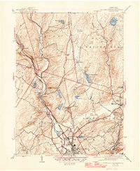
 1950 Scranton1952 Print · USGSMid-century Northeast Pennsylvania and the Hudson Valley come alive in this survey of the tri-state region. Genealogists and historians can trace the dense rail networks of the Erie RR and DL&W RR between industrial hubs like Scranton and Wilkes-Barre.
 - 1953 Map of Scranton
 1953 Scranton1953 Print · USGSNortheastern Pennsylvania and the Catskills are shown in great detail during the early fifties, a time when rail lines and river valleys dictated the region's growth. Genealogists and historians can trace the industrial hearts of Scranton and Wilkes-Barre or locate remote landmarks like High Point and Lake Wallenpaupack.
 - 1953 Map of Stroudsburg
 1953 Stroudsburg1953 Print · USGSThe Pocono foothills and Lehigh Valley slate belt come into sharp focus in this mid-century survey of Monroe and Northampton counties. Genealogists and historians can trace family roots through numerous rural landmarks like Wolf School No 2, White Gap Cemetery, and the industrial Slate Quarries of Bangor.2 unique versions available
 - 1955 Map of Stroudsburg, 1957 Print
 1955 Stroudsburg1957 Print · USGSIn the mid-1950s, the Delaware Water Gap remained a vital crossroads of commerce and conservation. Researchers can trace the path of the Appalachian Trail or locate family roots at Prospect Cem and schools like St Matthew Sch.7 unique versions available
 - 1956 Map of Newark
 1956 Newark1956 Print · USGSThe industrial heart of the Mid-Atlantic is captured here at the dawn of the highway era, tracing the dense corridors between Newark and Philadelphia. Genealogists and local historians can map the rail networks of the Reading RR or locate mid-century military life at Fort Dix Military Reservation.2 unique versions available
 - 1957 Map of Newark
 1957 Newark1957 Print · USGSThe industrial and military heart of the Mid-Atlantic is mapped during its post-war suburban boom. Genealogists and historians can trace the intricate rail corridors of the Reading Railroad and locate key landmarks from Princeton University to Fort Hancock.
 - 1959 Map of Scranton
 1959 Scranton1959 Print · USGSThe northern coalfields and the Hudson Valley meet in this mid-century survey of the Pennsylvania and New York borderlands. Genealogists and historians can trace the intricate rail networks of the Erie Railroad and the vast waters of Lake Wallenpaupack.2 unique versions available
 - 1959 Map of Pocono
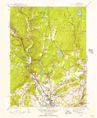
 1959 Pocono1959 Print · USGSThe Pocono Mountains region is captured here in the late fifties, showcasing its evolution from a railway-dependent timber and ice landscape to a premier resort destination. Researchers can locate dozens of country schoolhouses like Maplewood Sch and trace the paths of the Erie RR through Hawley and Kimbles.
 - 1960 Map of Newark
 1960 Newark1960 Print · USGSThe industrial heart of the Mid-Atlantic is shown at mid-century, stretching from the dense urban centers of Newark and Philadelphia to the Blue Mountain ridges. Researchers can trace historic rail lines, coastal defenses at Fort Hancock, and the riverfront growth of Trenton and Easton.3 unique versions available
 - 1962 Map of Scranton, 1977 Print
 1962 Scranton1977 Print · USGSThe industrial heart of eastern Pennsylvania and the New York Catskills are captured here in the early sixties. Genealogists and historians can trace the dense valley settlements from Scranton to Wilkes-Barre and the rail lines of the Erie Lackawanna Railroad.2 unique versions available
 - 1964 Map of Newark
 1964 Newark1964 Print · USGSGreater New Jersey and eastern Pennsylvania appear at the peak of their industrial and rail-centered development in the mid-sixties. Genealogists and historians can trace the paths of the Pennsylvania RR, identify mid-century landmarks like CAMP KILMER, or follow the Schuylkill River through READING.2 unique versions available
 - 1965 Map of Scranton
 1965 Scranton1965 Print · USGSThe tri-state highlands of Pennsylvania, New York, and New Jersey come alive in the mid-sixties as industry and recreation converge. Trace the intricate rail lines of the Erie Lackawanna RR or locate landmarks like the U S Military Academy.2 unique versions available
Showing maps 1-25 of 43
Top cities near Arlington Heights
- East Stroudsburg historical maps
- Tobyhanna historical maps
- Blairstown historical maps
- Stroudsburg historical maps
- Bangor historical maps
- Pen Argyl historical maps
See more
Top neighborhoods of Arlington Heights
Frequently asked questions
- What are the different types of historical maps available for Arlington Heights?
- What is the oldest map of Arlington Heights?
- Where can I purchase historical maps of Arlington Heights for my home or office?
- Where can I download high-res historical maps of Arlington Heights?
- Are there historical topographic maps available for Arlington Heights?
- Is there historical aerial imagery available for Arlington Heights?
- Where are historical maps of Arlington Heights sourced from?