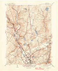
1947 Map of East Stroudsburg
USGS Topo · Published 1947About this map
The Pocono Mountains terrain defines this mid-century view of the area surrounding East Stroudsburg, where the waters of Brodhead Creek and Marshall Creek descend through the valley. This period shows a landscape of small settlements and rural infrastructure before major modern expansion, featuring local landmarks like Stites Bridge and the small aviation hub at Pipher Airport. The map captures the social geography of the era through several local institutions, including the Beakleyville Ch, Lesoine Sch, and the Franklin Hill Cem.
Find a feature on this map
45 named features on this map. Tap any name to fly to it.
Don’t see what you’re looking for? This feature index may not catch every label — zoom into the map to look around manually.
Map Details
Editions of this 1947 East Stroudsburg Map
2 editions found
Other maps of this area

1891 · Delaware Water Gap
USGS Topo · 1:62,500

1893 · Delaware Water Gap
USGS Topo · 1:62,500

1914 · Wind Gap
USGS Topo · 1:62,500

1916 · Wind Gap
USGS Topo · 1:62,500

1919 · Pocono
USGS Topo · 1:62,500

1921 · Pocono
USGS Topo · 1:62,500

1923 · Pocono
USGS Topo · 1:62,500

1924 · Bushkill
USGS Topo · 1:48,000

1936 · Delaware Water Gap
USGS Topo · 1:48,000

1941 · Delaware Water Gap
USGS Topo · 1:62,500
Featured Places
- Paradise Township, PA
- Analomink, Stroud Township
- Marshalls Creek, Smithfield Township
- Middle Smithfield Township, PA
- Arlington Heights, Stroud Township