1940s Maps of Limerick Township, Pennsylvania
Explore 7 historic maps of Limerick Township from the 1940s. These maps offer a rare glimpse into what life looked like during the 1940s — showing old roads, neighborhoods, homes, and landmarks that have changed or disappeared over time.
Whether you're researching your family's past, planning a metal detecting trip, or studying how Limerick Township's landscape evolved across the 1940s, these high-resolution maps are a powerful tool for exploring the history of this region.
- Focus on a specific era: All maps on this page are from the 1940s, giving you a focused view of this time period.
- See what’s changed: Compare century-old streets, trails, and buildings to today's modern landscape using overlays and satellite layers.
- Research with precision: Use these maps for genealogy, historical research, land use analysis, or educational projects.
- View, download, or print: Maps are fully viewable online in high resolution, and can be downloaded or printed for your own records.
Start exploring Limerick Township's history through authentic maps from the 1940s. This is your window into the past.
Limerick Township, PA maps
(7)- 1942 Map of Norristown
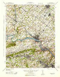
 1942 Norristown1942 Print · USGSSoutheastern Pennsylvania at the onset of World War II shows a landscape of busy industrial river towns and expanding rail suburbs. Genealogists and historians can trace the early transit networks connecting Norristown, Doylestown, and the riverfront at New Hope.
 - 1943 Map of Norristown
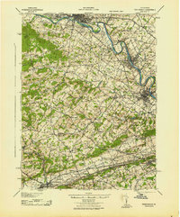
 1943 Norristown1943 Print · USGSMontgomery County in the early 1940s is a thriving network of rail-side industrial hubs and established borough centers. Genealogists and local historians can trace the development of Norristown and Lansdale or locate landmarks like the Eastern State Penitentiary.
 - 1943 Map of Sassamansville
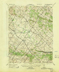 1943 Sassamansville1943 Print · USGSMontgomery County was a patchwork of small townships and crossroads hamlets during the mid-forties. Genealogists and local historians can trace the early footprints of Gilbertsville, Sassamansville, and Frederick, or locate the specific grounds of Ringing Rock Park.
 - 1943 Map of Phoenixville
 1943 Phoenixville1943 Print · USGSSoutheastern Pennsylvania during the early war years shows a landscape defined by the winding Schuylkill River and heavy rail traffic. Genealogists and historians can trace the early Pennsylvania Turnpike and explore historic locales like Fricks Lock and Nantmeal Village.
 - 1943 Map of Perkiomenville
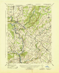 1943 Perkiomenville1943 Print · USGSThe Perkiomen Valley was a landscape of winding creeks and rail-stop villages during the early 1940s. Genealogists and local historians can trace family roots through settlements like Perkiomenville, Schwenksville, and Shirks Corner along the READING railroad line.
 - 1944 Map of Newark, 1971 Print
 1944 Newark1971 Print · USGSThe industrial corridor from Philadelphia to New York was in a period of massive transition during the mid-forties. Genealogists and researchers can trace the rail lines of the Lehigh Valley RR, locate military installations like Picatinny Arsenal, and explore the early sprawl near Levittown.5 unique versions available
 - 1949 Map of Newark
 1949 Newark1949 Print · USGSThe industrial corridor between Philadelphia and New York comes alive in this post-war survey. Genealogists and historians can trace the massive rail networks of the Reading Railroad and locate major installations like Fort Dix or Picatinny Arsenal.2 unique versions available
End of results
Showing maps 1-7 of 7
Top cities near Limerick Township
- Norristown historical maps
- Radnor Township historical maps
- Pottstown historical maps
- West Goshen Township historical maps
- King of Prussia historical maps
- Phoenixville historical maps
See more
Top neighborhoods of Limerick Township
- Fruitville historical maps
- Neiffer historical maps
- Linfield historical maps
- Lindberg Heights historical maps
- Pineview Estates historical maps
- Barlow Heights historical maps
See more
Frequently asked questions
- What are the different types of historical maps available for Limerick Township?
- What is the oldest map of Limerick Township?
- Where can I purchase historical maps of Limerick Township for my home or office?
- Where can I download high-res historical maps of Limerick Township?
- Are there historical topographic maps available for Limerick Township?
- Is there historical aerial imagery available for Limerick Township?
- Where are historical maps of Limerick Township sourced from?