1990s Maps of Wheatfield Township, Pennsylvania
Explore 1 historic maps of Wheatfield Township from the 1990s. These maps offer a rare glimpse into what life looked like during the 1990s — showing old roads, neighborhoods, homes, and landmarks that have changed or disappeared over time.
Whether you're researching your family's past, planning a metal detecting trip, or studying how Wheatfield Township's landscape evolved across the 1990s, these high-resolution maps are a powerful tool for exploring the history of this region.
- Focus on a specific era: All maps on this page are from the 1990s, giving you a focused view of this time period.
- See what’s changed: Compare century-old streets, trails, and buildings to today's modern landscape using overlays and satellite layers.
- Research with precision: Use these maps for genealogy, historical research, land use analysis, or educational projects.
- View, download, or print: Maps are fully viewable online in high resolution, and can be downloaded or printed for your own records.
Start exploring Wheatfield Township's history through authentic maps from the 1990s. This is your window into the past.
Wheatfield Township, PA maps
(1)- 1999 Map of Wertzville, 2001 Print
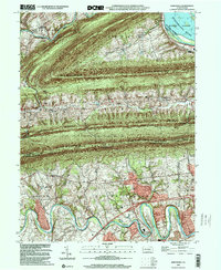 1999 Wertzville2001 Print · USGSPerry and Cumberland counties meet along a series of prominent mountain ridges at the turn of the millennium. Researchers can trace local heritage at Hustons Mill, Oak Grove Cemetery, and several rural school sites like Elliotts School and Summers School.
End of results
Showing maps 1-1 of 1
Top cities near Wheatfield Township
- Harrisburg historical maps
- Carlisle historical maps
- New Cumberland historical maps
- Lower Allen historical maps
- Camp Hill historical maps
- Middlesex Township historical maps
See more
Top neighborhoods of Wheatfield Township
- Losh Run historical maps
- Rose Glen historical maps
- Montebello historical maps
- Mecks Corner historical maps
- Dellville historical maps
Frequently asked questions
- What are the different types of historical maps available for Wheatfield Township?
- What is the oldest map of Wheatfield Township?
- Where can I purchase historical maps of Wheatfield Township for my home or office?
- Where can I download high-res historical maps of Wheatfield Township?
- Are there historical topographic maps available for Wheatfield Township?
- Is there historical aerial imagery available for Wheatfield Township?
- Where are historical maps of Wheatfield Township sourced from?