1990s Maps of Porter Township, Pennsylvania
Explore 11 historic maps of Porter Township from the 1990s. These maps offer a rare glimpse into what life looked like during the 1990s — showing old roads, neighborhoods, homes, and landmarks that have changed or disappeared over time.
Whether you're researching your family's past, planning a metal detecting trip, or studying how Porter Township's landscape evolved across the 1990s, these high-resolution maps are a powerful tool for exploring the history of this region.
- Focus on a specific era: All maps on this page are from the 1990s, giving you a focused view of this time period.
- See what’s changed: Compare century-old streets, trails, and buildings to today's modern landscape using overlays and satellite layers.
- Research with precision: Use these maps for genealogy, historical research, land use analysis, or educational projects.
- View, download, or print: Maps are fully viewable online in high resolution, and can be downloaded or printed for your own records.
Start exploring Porter Township's history through authentic maps from the 1990s. This is your window into the past.
Porter Township, PA maps
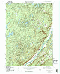
(11)- 1992 Map of Pecks Pond, 1995 Print
 1992 Pecks Pond1995 Print · USGSThe Pocono Mountains in the early nineties reveal a landscape of dense state forests and growing residential enclaves. Genealogists and researchers can trace the development of Hemlock Farms and find landmarks like Pecks Pond, Lords Valley, and the Rock Hill Camp.
 - 1992 Map of Edgemere, 1995 Print
 1992 Edgemere1995 Print · USGSPike County in the early 1990s was a landscape of dense state forests and growing residential lake communities. Genealogists and researchers can trace the development of summer retreats like Sagamore Estates and find local landmarks such as Silver Lake and the Cem near Gin Brook.
 - 1994 Map of Skytop, 1995 Print
 1994 Skytop1995 Print · USGSMonroe and Pike Counties were centers for forest recreation and mountain retreats in the mid-1990s. Researchers can trace old woods roads and find family landmarks like the McComas Cem and early camp sites at Lake Lenape or Otter Lake.
 - 1994 Map of Lake Maskenozha, 1995 Print
 1994 Lake Maskenozha1995 Print · USGSThe Pennsylvania-New Jersey borderlands in the mid-1990s show a mix of protected state forests and summer camps. Researchers can trace historic sites like Egypt Mills, find old structures at Wallpack Center, and locate natural landmarks including Dingmans Falls and Shapnack Island.
 - 1994 Map of Promised Land, 1995 Print
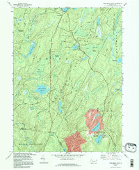
 1994 Promised Land1995 Print · USGSPike County was a center for public conservation and wilderness recreation in the mid-1990s. Genealogists and hikers can trace the roads around Blooming Grove or locate landmarks like the Good Shepherd Ch and the Lookout Tower.
 - 1994 Map of Twelvemile Pond, 1996 Print
 1994 Twelvemile Pond1996 Print · USGSThe Pocono plateau in the mid-1990s reveals a landscape of dense wetlands and forest preserves managed by the state. Researchers can trace the layout of secluded settlements like Ludleyville and resort areas such as Tamiment and Unity House.
 - 1995 Map of Lake Maskenozha, 1998 Print
 1995 Lake Maskenozha1998 Print · USGSPike County and the Delaware River valley are shown in the 1990s as a haven for summer camps and state forest land. Researchers can locate early industrial sites like Haney's Mill and landmarks such as Holy Trinity Ch or Wallpack Center.
 - 1997 Map of Promised Land, 1998 Print
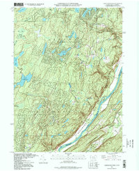
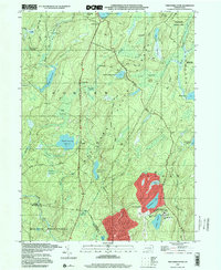
 1997 Promised Land1998 Print · USGSThe Pocono Plateau comes into focus in the late nineties, showing a landscape of deep forests and glacial lakes. Genealogists and hikers can trace the foundations of Roemersville, the Blooming Grove Sch, and the shores of Bruce Lake.
 - 1997 Map of Pecks Pond, 1999 Print
 1997 Pecks Pond1999 Print · USGSThe Pocono plateau of the late nineties is revealed here as a landscape of forest conservation and growing woodland communities. Researchers can trace the layout of Hemlock Farms, locate the namesake Pecks Pond, and find recreation sites like Rock Hill Camp.
 - 1997 Map of Skytop, 2000 Print
 1997 Skytop2000 Print · USGSMonroe and Pike Counties are shown here during the late twentieth century, when this region of the Poconos was defined by its vast state forests and mountain retreats. Researchers can trace land use at Skytop, locate the McComas Cem, and find old camps like Camp William Penn.
 - 1997 Map of Twelvemile Pond, 2000 Print
 1997 Twelvemile Pond2000 Print · USGSPike County at the end of the nineties shows a wilderness shaped by both conservation and resort development. Researchers can trace the network of trails through Thunder Swamp or locate local landmarks like the Township Hall and Unity House.
End of results
Showing maps 1-11 of 11
Top cities near Porter Township
- East Stroudsburg historical maps
- Delaware historical maps
- Blairstown historical maps
- Lackawaxen Township historical maps
- Hampton Township historical maps
- Blooming Grove Township historical maps
See more
Top neighborhoods of Porter Township
Frequently asked questions
- What are the different types of historical maps available for Porter Township?
- What is the oldest map of Porter Township?
- Where can I purchase historical maps of Porter Township for my home or office?
- Where can I download high-res historical maps of Porter Township?
- Are there historical topographic maps available for Porter Township?
- Is there historical aerial imagery available for Porter Township?
- Where are historical maps of Porter Township sourced from?