1960s Maps of Potter County, Pennsylvania
Explore 19 historic maps of Potter County from the 1960s. These maps offer a rare glimpse into what life looked like during the 1960s — showing old roads, neighborhoods, homes, and landmarks that have changed or disappeared over time.
Whether you're researching your family's past, planning a metal detecting trip, or studying how Potter County's landscape evolved across the 1960s, these high-resolution maps are a powerful tool for exploring the history of this region.
- Focus on a specific era: All maps on this page are from the 1960s, giving you a focused view of this time period.
- See what’s changed: Compare century-old streets, trails, and buildings to today's modern landscape using overlays and satellite layers.
- Research with precision: Use these maps for genealogy, historical research, land use analysis, or educational projects.
- View, download, or print: Maps are fully viewable online in high resolution, and can be downloaded or printed for your own records.
Start exploring Potter County's history through authentic maps from the 1960s. This is your window into the past.
Potter County, PA maps
(19)- 1960 Map of Buffalo
 1960 Buffalo1960 Print · USGSWestern New York and the Niagara Peninsula thrive during the mid-twentieth century industrial peak. Genealogists and historians can trace family-named points and early settlements from Dunkirk Light to the Allegany Indian Reservation.
 - 1960 Map of Williamsport
 1960 Williamsport1960 Print · USGSNorth-central Pennsylvania in the mid-twentieth century was a vital corridor of rail and river industry stretching from the New York line to the coal regions. Genealogists can trace the rail networks of the Pennsylvania RR and Lehigh Valley RR connecting towns like Williamsport, Towanda, and Lock Haven.
 - 1962 Map of Williamsport, 1966 Print
 1962 Williamsport1966 Print · USGSNorth-central Pennsylvania was a landscape of industrial river hubs and vast state woodlands in the early sixties. Researchers can trace the path of the Pennsylvania Railroad through Williamsport and explore the remote reaches of Bucktail State Park.5 unique versions available
 - 1962 Map of Buffalo, 1980 Print
 1962 Buffalo1980 Print · USGSThe Niagara Frontier and Western New York are captured here in the early sixties, showing the vital industrial and maritime nexus between the U.S. and Canada. Researchers can trace the path of the Welland Canal, locate the Allegany Indian Reservation, or find family sites near Chautauqua Lake.2 unique versions available
 - 1965 Map of Williamsport
 1965 Williamsport1965 Print · USGSNorth-central Pennsylvania in the mid-1960s is defined by the industrial river towns and vast timberlands of the Allegheny Plateau. Researchers can trace historic rail lines like the Erie Lackawanna and Reading as they thread through Williamsport, Lock Haven, and Jersey Shore.
 - 1965 Map of Allentown, 1966 Print
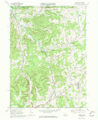
 1965 Allentown1966 Print · USGSAllegany County during the mid-1960s reveals a landscape defined by its petroleum heritage and deep valley settlements. Researchers can trace the extensive network of Oil Wells across Bow Ridge, find family plots at Dimmick Cem, and locate the small communities of Allentown and Petrolia.
 - 1965 Map of Bolivar, 1967 Print
 1965 Bolivar1967 Print · USGSAllegany County oil and gas fields are in full operation during the mid-sixties, showing a landscape shaped by energy and rail. Genealogists can trace family plots at Little Genesee Cem or follow the old Pittsburgh Shawmut and Northern Railroad line.2 unique versions available
 - 1966 Map of Williamsport
 1966 Williamsport1966 Print · USGSThe Susquehanna Valley was a hub of transit and industry in the mid-seventies, where the river's West Branch connected major college towns and timberlands. Researchers can trace historical rail lines like the Reading or locate regional landmarks from Jersey Shore to Ricketts Glen State Park.
 - 1967 Map of Buffalo
 1967 Buffalo1967 Print · USGSWestern New York and the Lake Erie shoreline are shown here during the mid-1960s industrial peak. Researchers can trace the massive rail networks of the Erie Railroad, locate the Cattaraugus Indian Reservation, or find historic sites like Fort Erie.
 - 1969 Map of West Pike
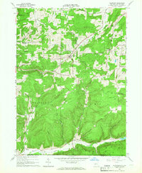
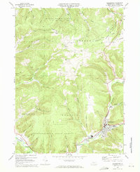
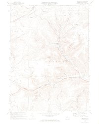
 1969 West Pike1969 Print · USGSPotter County in the late sixties reveals a landscape where remote timberlands meet small valley settlements. You can trace old family landmarks and industrial footprints through sites like Loucks Mills, the Quarries, and a hillside Cem.3 unique versions available
 - 1969 Map of Sabinsville, 1972 Print
 1969 Sabinsville1972 Print · USGSTioga County's timber and gas country is preserved here as it was in the late sixties, centered on the Sabinsville and Gaines settlements. Genealogists and historians can trace the Galeton and Addison rail line and locate old family burial grounds like Lovel Cem and Baker Cem.3 unique versions available
 - 1969 Map of Coudersport, 1972 Print
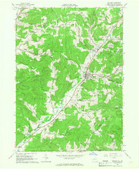
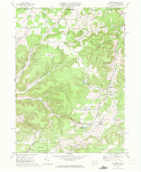
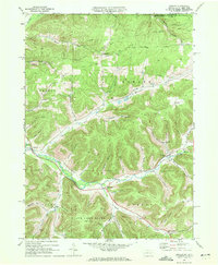
 1969 Coudersport1972 Print · USGSThe Allegheny River valley at the close of the sixties shows a landscape of deep hollows and growing industry. Trace the Old Allegheny Railroad Grade through Olmsted or locate family roots at St Eulalia Cem and the High Sch in Coudersport.3 unique versions available
 - 1969 Map of Roulette, 1972 Print
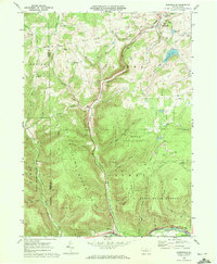
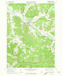
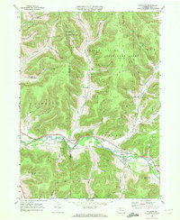 1969 Roulette1972 Print · USGSThe Allegheny River valley in Potter County comes into focus during the late sixties, showing a landscape shaped by timber, gas, and rail. Researchers can find family landmarks like Lyman Cem, the Drive-in Theater near Burtville, and an Old RR Grade.4 unique versions available
 - 1969 Map of Ellisburg, 1972 Print
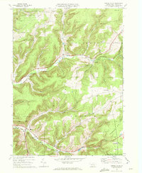
 1969 Ellisburg1972 Print · USGSPotter County, Pennsylvania, is shown during the late sixties as an active hub for the regional energy industry. Genealogists and historians can trace family locations near Andrews Settlement, the path of the Old Oswayo Railroad Grade, and Rose Lake.3 unique versions available
 - 1969 Map of Sweden Valley, 1972 Print
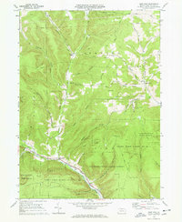
 1969 Sweden Valley1972 Print · USGSPotter County’s high country in the late sixties shows a landscape defined by the headwaters of the Allegheny River and the expansion of the natural gas industry. Researchers can trace family-named hollows, rural burial sites like Ford Hill Cem, and local landmarks like the Potato City Airfield.
 - 1969 Map of Shinglehouse, 1972 Print
 1969 Shinglehouse1972 Print · USGSThe Oswayo Creek valley in the late sixties reveals a landscape shaped by the Shinglehouse Oil Field and the borough of Shinglehouse. Researchers can trace old family landmarks and rural communities from Myrtle and East Sharon to the Maple Grove Cem and Bell Run Union Ch.2 unique versions available
 - 1969 Map of Brookland, 1972 Print
 1969 Brookland1972 Print · USGSPotter County’s highland valleys are captured here in the late sixties, showing a landscape defined by state forests and rural crossroads. Genealogists can locate family landmarks like Oak Hall Sch and the Sweden Hill Ch alongside the rails of the Addison and Galeton.4 unique versions available
 - 1969 Map of Oswayo, 1972 Print
 1969 Oswayo1972 Print · USGSPotter County's northern hollows are captured here in the late sixties, showing a landscape shaped by petroleum extraction and old rail routes. Researchers can trace the Oswayo Creek Grade through Millport or locate family sites near the Rathbone Cem and Kibbeville.4 unique versions available
 - 1969 Map of Ulysses, 1972 Print
 1969 Ulysses1972 Print · USGSPotter County at the end of the sixties shows a landscape of river-fed valleys and energy infrastructure. Trace local history through North Bingham Cem, the Hickox Landing Field, and old transport routes like Pusher Siding.2 unique versions available
End of results
Showing maps 1-19 of 19
Top cities of Potter County
- Roulette Township historical maps
- Galeton historical maps
- Shinglehouse historical maps
- Harrison Township historical maps
- Genesee Township historical maps
- Sweden Township historical maps
See more
Frequently asked questions
- What are the different types of historical maps available for Potter County?
- What is the oldest map of Potter County?
- Where can I purchase historical maps of Potter County for my home or office?
- Where can I download high-res historical maps of Potter County?
- Are there historical topographic maps available for Potter County?
- Is there historical aerial imagery available for Potter County?
- Where are historical maps of Potter County sourced from?