1990s Maps of Potter County, Pennsylvania
Explore 11 historic maps of Potter County from the 1990s. These maps offer a rare glimpse into what life looked like during the 1990s — showing old roads, neighborhoods, homes, and landmarks that have changed or disappeared over time.
Whether you're researching your family's past, planning a metal detecting trip, or studying how Potter County's landscape evolved across the 1990s, these high-resolution maps are a powerful tool for exploring the history of this region.
- Focus on a specific era: All maps on this page are from the 1990s, giving you a focused view of this time period.
- See what’s changed: Compare century-old streets, trails, and buildings to today's modern landscape using overlays and satellite layers.
- Research with precision: Use these maps for genealogy, historical research, land use analysis, or educational projects.
- View, download, or print: Maps are fully viewable online in high resolution, and can be downloaded or printed for your own records.
Start exploring Potter County's history through authentic maps from the 1990s. This is your window into the past.
Potter County, PA maps
(11)- 1994 Map of Galeton, 1995 Print
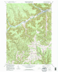 1994 Galeton1995 Print · USGSThe Potter County highlands near the end of the twentieth century remain a landscape of deep hollows and isolated hamlets. Genealogists and local historians can trace family locations at West Hill Cem, Germania, and the remote Carter Camp settlement.
 - 1994 Map of Conrad, 1999 Print
 1994 Conrad1999 Print · USGSPotter County's deep woods and steep valleys are shown here in the mid-1990s, centered on the winding Sinnemahoning Creek East Fork. Researchers can trace old family burial grounds at Brooks Cem and follow forest paths like the Nelson Trail through Susquehannock State Forest.
 - 1994 Map of Emporium, 1999 Print
 1994 Emporium1999 Print · USGSEmporium and the surrounding northern Pennsylvania highlands appear here at a time when the region's vast state forests and parks had fully matured. Genealogists and hikers can trace family names in Newton Cem or explore the rugged drainage of Sinnemahoning Creek via the Mc Dowell Trail.2 unique versions available
 - 1994 Map of Slate Run, 1999 Print
 1994 Slate Run1999 Print · USGSThe wilderness at the junction of Lycoming, Potter, and Clinton counties is captured here in the 1990s. Local researchers can trace the rugged topography of Pine Creek Gorge, the isolated settlement of Slate Run, and the high-elevation Pump Station Fire Tower.
 - 1994 Map of Young Womans Creek, 1999 Print
 1994 Young Womans Creek1999 Print · USGSThe northern Pennsylvania wilderness of the 1990s is captured here, showing the junction of the Susquehannock State Forest and Sproul State Forest. Genealogists and hikers can trace the many drainages of Young Womans Creek, from Lecox Ridge down into Pifer Valley.
 - 1994 Map of Cherry Springs, 1999 Print
 1994 Cherry Springs1999 Print · USGSPotter County’s high plateaus are shown in the 1990s as a haven for conservation and mountain recreation within the Susquehannock State Forest. Trace historical paths and forest infrastructure like the Cherry Springs Fire Tower, the Railroad Trail, and Lyman Run Camp.
 - 1994 Map of Hammersley Fork, 1999 Print
 1994 Hammersley Fork1999 Print · USGSClinton and Potter Counties are shown here in the 1990s, dominated by the winding valley of Kettle Creek. Genealogists and local historians can locate Hammersley Fork, trace the grounds of Summerson Cem, or find the former Central Sch.
 - 1994 Map of Lee Fire Tower, 1999 Print
 1994 Lee Fire Tower1999 Print · USGSThe convergence of three state forests in the Pennsylvania highlands is documented in the mid-1990s, showing a land of deep hollows and timber ridges. Researchers can trace forest industrial history via the CLAY MINE, PIPELINE ROAD, and the landmark Lee Fire Tower.
 - 1994 Map of Tamarack, 1999 Print
 1994 Tamarack1999 Print · USGSClinton and Potter counties are shown here in the mid-1990s, capturing a landscape defined by the deep woods of the Susquehannock and Sproul State Forests. Researchers can locate the Tamarack Lookout Tower, the small settlement of Cross Fork, and the Tamarack Swamp Natural Area.
 - 1994 Map of Wharton, 1999 Print
 1994 Wharton1999 Print · USGSThe First Fork Sinnemahoning valley in Potter County remained a heartland of state forestry and small river settlements in the late twentieth century. Genealogists can locate family landmarks such as Wharton Cem, Rees Cem, and the old Reesville Sch site.
 - 1995 Map of Oleona
 1995 Oleona1995 Print · USGSThe deep valleys of Potter County are captured here in the mid-nineties, showing a landscape defined by forestry and state parklands. Researchers can trace historic trails and remote landmarks like Ole Bull State Park, the Yochum Hill Cem, and the village of Oleona.
End of results
Showing maps 1-11 of 11
Top cities of Potter County
- Roulette Township historical maps
- Galeton historical maps
- Shinglehouse historical maps
- Harrison Township historical maps
- Genesee Township historical maps
- Sweden Township historical maps
See more
Frequently asked questions
- What are the different types of historical maps available for Potter County?
- What is the oldest map of Potter County?
- Where can I purchase historical maps of Potter County for my home or office?
- Where can I download high-res historical maps of Potter County?
- Are there historical topographic maps available for Potter County?
- Is there historical aerial imagery available for Potter County?
- Where are historical maps of Potter County sourced from?