Old Maps of Potter County, Pennsylvania for Academic Research
Study the evolution of Potter County with 249 high-resolution historic maps. Whether you're teaching, researching, or modeling changes in land use, these maps provide essential visual documentation of urban, environmental, and geographic change.
- Analyze long-term change: Track patterns in development, transportation, and natural features.
- Ideal for environmental or urban studies: Support academic projects with primary historical map data.
- Use in the classroom or lab: Educators and researchers rely on these maps to bring historical context to life.
These maps are a powerful tool for teaching, research, and visualizing how Potter County has changed over the decades.
Potter County, PA maps
(249)- 1899 Map of Gaines, 1960 Print
 1899 Gaines1960 Print · USGSPotter and Tioga Counties are seen here at the end of the nineteenth century, as the logging and rail industries reached into every deep hollow. Genealogists and historians can trace family lands near Harrison Valley, Sabinsville, and the remote Loucks Mills.2 unique versions available
 - 1900 Map of Gaines
 1900 Gaines1900 Print · USGSThe Cowanesque River valley at the turn of the century shows a landscape defined by new rail lines and remote timbering settlements. Genealogists can trace family holdings near Sunderlinville, Harrison Valley, and the rural crossroads of Mixtown and Lansing.5 unique versions available
 - 1925 Map of Belmont
 1925 Belmont1925 Print · USGSAllegany County hills and river valleys are shown in the mid-twenties, centered on the railroad hubs and rural townships. Trace the tracks of the Erie RR and Shawmut RR past local landmarks like School No 5 and Richburg.4 unique versions available
 - 1932 Map of Genesee, 1961 Print
 1932 Genesee1961 Print · USGSNorthern Pennsylvania’s high plateau is captured here in the early thirties, showing the transition from timber-hauling rail lines to mountain highways. Genealogists can locate family names at Andrews Settlement, the Sweden Hill Cem, or the Ice Mine.
 - 1934 Map of Coudersport
 1934 Coudersport1934 Print · USGSPotter and McKean Counties appear here in the mid-1930s, showing a landscape of deep hollows and river-valley rail towns. Genealogists can trace family names through dozens of rural landmarks like Sartwell Cr Ch, Knowlton Station, and Shinglehouse.3 unique versions available
 - 1937 Map of Genesee
 1937 Genesee1937 Print · USGSPotter County’s high plateau is captured in the 1930s when the headwaters of the Allegheny River and Genesee River met a complex network of mountain railroads. Genealogists can locate family landmarks like Sweden Hill Cem, the Ice Mine, and numerous district schools including Judd Sch.3 unique versions available
 - 1938 Map of Coudersport
 1938 Coudersport1938 Print · USGSNorthern Pennsylvania during the mid-1930s was a landscape of deep hollows and river-bottom settlements tied to the Allegheny and Oswayo. Researchers can trace the placement of rural landmarks like Crandall Hill Fire Tower, Sartwell Creek Ch, and the Plank Road Sch.3 unique versions available
 - 1939 Map of Belmont, 1961 Print
 1939 Belmont1961 Print · USGSAllegany County highlands at the end of the 1930s show a landscape shaped by the Genesee River and the legacy of the Pittsburg Shawmut and Northern RR. Genealogists can trace family school districts like Carnahan Sch or explore the early footprints of Richburg and Little Genesee.2 unique versions available
 - 1943 Map of Hyner
 1943 Hyner1943 Print · USGSIn the central Pennsylvania highlands during the mid-1940s, the river and rail lines dictated the life of the valley. Researchers can trace the industrial corridor from Renovo Boro to remote outposts like Slate Run and Young Womanstown.
 - 1945 Map of Driftwood, 1953 Print
 1945 Driftwood1953 Print · USGSCameron County communities thrive along the river bends and rail lines at the end of World War II. Researchers can trace the dual rail paths of the Pennsylvania and Baltimore and Ohio railroads through Driftwood and locate the First Fork Sch.4 unique versions available
 - 1945 Map of First Fork, 1954 Print
 1945 First Fork1954 Print · USGSThe deep valleys of Cameron and Potter counties appear here in the mid-1940s, centered on the First Fork Sinnemahoning Creek corridor. Local researchers can locate the First Fork School, Gilmore Cem, and early ridge-top routes like Square Timber Road.3 unique versions available
 - 1946 Map of Young Womans Creek
 1946 Young Womans Creek1946 Print · USGSClinton County and the surrounding high ridges were deeply forested and sparsely settled in the late 1940s. Genealogists and historians can trace old timber and utility routes like the Underground Pipe Line, Greenlick Road, and the curiously named Bobsled Trail.4 unique versions available
 - 1946 Map of Renovo East, 1953 Print
 1946 Renovo East1953 Print · USGSThe industrial corridor of the West Branch Susquehanna River is seen here in the mid-1940s, showing the critical rail infrastructure of the Pennsylvania railroad. Genealogists can trace family sites in Gleasonton or Farwell and locate the St Josephs Cem.3 unique versions available
 - 1946 Map of Renovo West, 1953 Print
 1946 Renovo West1953 Print · USGSClinton County's river valleys and ridgelines come alive in this mid-century survey of the Pennsylvania wilds. Trace the industrial footprint of the Pennsylvania RR through Renovo or find family history at Laurel Hill Cem and Summerson Cem.9 unique versions available
 - 1946 Map of Hammersley Fork, 1954 Print
 1946 Hammersley Fork1954 Print · USGSThe deep valleys of north-central Pennsylvania appear just after the war as small creek-side settlements remain the primary nodes of local life. Genealogists can trace family names at Summerson Cem and McCoy Cem or locate the old Central Sch near Hammersley Fork.4 unique versions available
 - 1946 Map of Tamarack, 1955 Print
 1946 Tamarack1955 Print · USGSClinton and Potter Counties appear in the mid-forties as a landscape of deep valleys and vital watershed headwaters. Genealogists and historians can trace the remote highlands surrounding Tamarack, locating local landmarks like Browns Mill and the Tamarack Lookout Tower.4 unique versions available
 - 1946 Map of Slate Run, 1958 Print
 1946 Slate Run1958 Print · USGSThe wilderness of Lycoming and Clinton counties comes into focus in the mid-1940s, highlighting the riverside rail economy and high-plateau landmarks. Genealogists and researchers can trace the New York Central railroad, the Slate Run settlement, and the Pump Station Fire Tower.4 unique versions available
 - 1947 Map of First Fork
 1947 First Fork1947 Print · USGSNorth-central Pennsylvania's mountain valleys are captured here in the mid-1940s, as small settlements and logging-era roads traced the winding First Fork Sinnemahoning Creek. Genealogists can locate the First Fork Sch and family burial sites like Smith Cem and Gilmore Cem.2 unique versions available
 - 1947 Map of Conrad, 1952 Print
 1947 Conrad1952 Print · USGSPotter County’s timbered ridges and deep hollows are captured here just after the war, showing a rural landscape before modern development. Researchers can locate family cemeteries like Angell Cem and Reed Cem, or trace the old Jersey Shore Turnpike.4 unique versions available
 - 1947 Map of Galeton, 1953 Print
 1947 Galeton1953 Print · USGSThe Pennsylvania Wilds around Galeton are captured here just after the war, showing a deeply timbered landscape of mountain ridges and narrow hollows. Genealogists can locate family cemeteries like Phoenix Cem and the legendary ruins of Ole Bull Castle.3 unique versions available
 - 1947 Map of Lee Fire Tower, 1954 Print
 1947 Lee Fire Tower1954 Print · USGSTioga, Potter, and Lycoming counties meet in this 1940s survey of the Pennsylvania Wilds. Researchers can trace historic industrial and forestry landmarks including the Lee Fire Tower, the Clay Mine Trail, and a remote Gas Well along the Cushman Br.5 unique versions available
 - 1947 Map of Conrad, 1956 Print
 1947 Conrad1956 Print · USGSPotter County’s deep valleys and timberlands are captured here in the mid-1940s as industry and nature intersected. Genealogists and hikers can trace old homesteads near Conrad, find the McFall Cem, and follow the historic Hammersley Trail.5 unique versions available
 - 1947 Map of Short Run, 1956 Print
 1947 Short Run1956 Print · USGSPotter County’s timbered ridges and deep hollows are documented here just after the war, showing the remote township corners and mountain trails. Trace family-named landmarks like Knickerbocker Hol and Yochum Run or find the early paths at Short Run.2 unique versions available
 - 1947 Map of Ayers Hill, 1957 Print
 1947 Ayers Hill1957 Print · USGSPotter County’s high ridges and deep hollows are captured here just after the war, showing a landscape defined by old family settlements and emerging recreation. Genealogists and hikers can trace early routes like the Coudersport Jersey Shore Turnpike or locate family sites like Anson Cem and the United Brethren Ch.3 unique versions available
 - 1947 Map of Oleona, 1958 Print
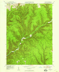 1947 Oleona1958 Print · USGSThe Potter County wilderness near the turn of the mid-century reveals the legacy of a famed Norwegian colony. Trace the sites of Ole Bull Castle (Ruins) and Oleona, or follow old paths like the Yochum Trail and Klondike Trail.3 unique versions available
Showing maps 1-25 of 249
Top cities of Potter County
- Roulette Township historical maps
- Galeton historical maps
- Shinglehouse historical maps
- Harrison Township historical maps
- Genesee Township historical maps
- Sweden Township historical maps
See more
Frequently asked questions
- What are the different types of historical maps available for Potter County?
- What is the oldest map of Potter County?
- Where can I purchase historical maps of Potter County for my home or office?
- Where can I download high-res historical maps of Potter County?
- Are there historical topographic maps available for Potter County?
- Is there historical aerial imagery available for Potter County?
- Where are historical maps of Potter County sourced from?