
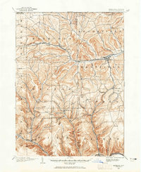
1899 Map of Gaines
USGS Topo · Published 1960About this map
Harrison Valley and Westfield serve as primary anchors along the northern edge of this Tioga and Potter County borderland. At the turn of the century, the region's economy is clearly defined by its geography and transit, with the Cowanesque River corridor supporting the New York Central and Hudson River R. R. and industrial sites like the Tannery. To the south, the landscape becomes a dense network of high ridges and deep hollows, such as Tubbs Hollow and Hardscrabble Hollow, which separate small agricultural and lumbering settlements. The Buffalo and Susquehanna R. R. (Genesee Division) follows the winding path of Pine Creek through the southwest, connecting remote outposts like Loucks Mills and West Pike to the broader market.
Find a feature on this map
70 named features on this map. Tap any name to fly to it.
Don’t see what you’re looking for? This feature index may not catch every label — zoom into the map to look around manually.
Map Details
Editions of this 1899 Gaines Map
2 editions found
Other maps of this area

1900 · Gaines
USGS Topo · 1:62,500

1900 · Elkland
USGS Topo · 1:62,500

1924 · Woodhull
USGS Topo · 1:48,000

1926 · Wellsville
USGS Topo · 1:62,500

1926 · Woodhull
USGS Topo · 1:62,500

1926 · Greenwood
USGS Topo · 1:62,500

1932 · Genesee
USGS Topo · 1:62,500

1937 · Genesee
USGS Topo · 1:62,500

1944 · Woodhull
USGS Topo · 1:62,500

1946 · Tiadaghton
USGS Topo · 1:24,000