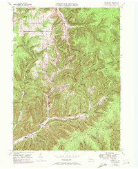
1947 Map of Ayers Hill
USGS Topo · Published 1972About this map
Ayers Hill and the surrounding high plateaus of Potter County are defined by a dense network of timber-era trails and narrow stream hollows in this mid-century survey. The landscape reflects a transition from early upland settlement to recreational use, anchored by the Coudersport Country Club in the north and state-managed lands to the south. Genealogists will find several family-named burial grounds, including Ayers Hill Cem, Jackson Cem, Reed Cem, and the remote Anton Cem near Fanton Hollow. The drainage patterns of the West Branch Pine Creek and Sinnemahoning Creek illustrate the geographical divide of the region, while named routes like the Jersey Shore Turnpike and White Birch Trail trace the historic movement of people through these steep valleys. Small settlements like Jenkins Hill and Bone appear alongside specialized landmarks such as Prouty Place Camp and Little Cherry Springs Park, providing a detailed look at rural Pennsylvania life before further modern development.
Find a feature on this map
60 named features on this map. Tap any name to fly to it.
Don’t see what you’re looking for? This feature index may not catch every label — zoom into the map to look around manually.
Map Details
Editions of this 1947 Ayers Hill Map
Other maps of this area

1932 · Genesee
USGS Topo · 1:62,500

1934 · Coudersport
USGS Topo · 1:48,000

1937 · Genesee
USGS Topo · 1:62,500

1938 · Coudersport
USGS Topo · 1:62,500

1947 · Conrad
USGS Topo · 1:62,500

1947 · Conrad
USGS Topo · 1:24,000

1947 · Short Run
USGS Topo · 1:24,000

1947 · Ayers Hill
USGS Topo · 1:24,000

1947 · Cherry Springs
USGS Topo · 1:24,000

1948 · Emporium
USGS Topo · 1:62,500
Featured Places
- Sweden Township, PA
- Borie, Summit Township
- Summit Township, PA
- Sylvania Township, PA
- Eulalia Township, PA