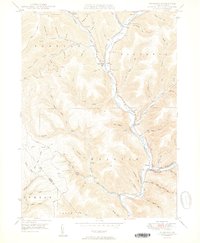
1950 Map of Wharton
USGS Topo · Published 1950About this map
First Fork Sinnemahoning Creek and its complex network of mountain runs dominate this Potter County landscape. In the mid-twentieth century, the settlements of Austin and Costello are established in the northern valleys, while the village of Wharton sits at the confluence of the East Fork Sinnemahoning Cr. The geography reflects a history of timber and resource extraction, evidenced by the Splash Dam on Bailey Run and a isolated Gas Well on the eastern ridges. Local genealogy is well-served by several rural burial grounds, including Forest Hill Cem, Costello Cem, St Joseph Cem, and Wharton Cem. The map captures a transition from industrial exploitation to a more stabilized rural settlement pattern, where small schools like Reesville Sch and landmarks like Chicago Springs Road Ridge anchored the community.
Find a feature on this map
61 named features on this map. Tap any name to fly to it.
Don’t see what you’re looking for? This feature index may not catch every label — zoom into the map to look around manually.
Map Details
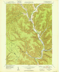
Editions of this 1950 Wharton Map
2 editions found
Other maps of this area

1945 · Driftwood
USGS Topo · 1:48,000

1945 · First Fork
USGS Topo · 1:24,000

1945 · Cameron
USGS Topo · 1:24,000

1946 · Renovo West
USGS Topo · 1:62,500

1946 · Hammersley Fork
USGS Topo · 1:24,000

1947 · Cameron
USGS Topo · 1:24,000

1947 · First Fork
USGS Topo · 1:24,000

1947 · Conrad
USGS Topo · 1:62,500

1947 · Conrad
USGS Topo · 1:24,000

1947 · Ayers Hill
USGS Topo · 1:24,000