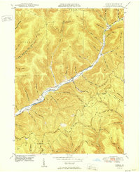
1950 Map of Conrad
USGS Topo · Published 1950About this map
Sinnemahoning Creek East Fork carves a deep valley through the high ridges of Potter County, serving as the primary corridor for movement and settlement in this corner of Pennsylvania. The village of Conrad sits at the northern end of this corridor, where Stony Lick Run meets the creek. The surrounding landscape is defined by its isolation and numerous named hollows, including Black Stump Hollow and McDonald Hollow, which suggest a history of specific land use or local family ties.
Find a feature on this map
59 named features on this map. Tap any name to fly to it.
Don’t see what you’re looking for? This feature index may not catch every label — zoom into the map to look around manually.
Map Details
Editions of this 1950 Conrad Map
This is the sole edition of this map. No revisions or reprints were ever made.
Other maps of this area

1945 · Driftwood
USGS Topo · 1:48,000

1945 · First Fork
USGS Topo · 1:24,000

1946 · Renovo West
USGS Topo · 1:62,500

1946 · Hammersley Fork
USGS Topo · 1:24,000

1946 · Tamarack
USGS Topo · 1:24,000

1947 · First Fork
USGS Topo · 1:24,000

1947 · Conrad
USGS Topo · 1:62,500

1947 · Conrad
USGS Topo · 1:24,000

1947 · Short Run
USGS Topo · 1:24,000

1947 · Ayers Hill
USGS Topo · 1:24,000
Featured Places
- Wharton Township, PA
- Summit Township, PA
- Sylvania Township, PA
- Hammersley, Wharton Township
- Logue, Wharton Township