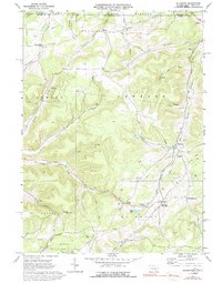
1969 Map of Ellisburg
USGS Topo · Published 1992About this map
Sharon Oil and Gas Field dominates the northwest corner of this 1969 survey, where the border of New York and Pennsylvania crosses high, narrow ridges. The landscape is defined by its deep drainage patterns, with Oswayo Creek and the West Branch Genesee River carving out a network of steep-walled hollows. Evidence of a prior industrial era is clearly visible along the Old Oswayo Railroad Grade, tracing a path through the valley near Ellisburg. Smaller settlements like Andrews Settlement and Reynoldstown are situated along these watercourses, often centered around a Union Ch or a quiet rural cemetery. The map documents an extensive energy infrastructure, including numerous Gas Wells, pipelines, and a storage facility, highlighting the region's continued reliance on subterranean resources long after the height of the local timber and rail era.
Find a feature on this map
48 named features on this map. Tap any name to fly to it.
Don’t see what you’re looking for? This feature index may not catch every label — zoom into the map to look around manually.
Map Details
Editions of this 1969 Ellisburg Map
3 editions found
Other maps of this area

1925 · Belmont
USGS Topo · 1:62,500

1926 · Wellsville
USGS Topo · 1:62,500

1932 · Genesee
USGS Topo · 1:62,500

1934 · Coudersport
USGS Topo · 1:48,000

1937 · Genesee
USGS Topo · 1:62,500

1938 · Coudersport
USGS Topo · 1:62,500

1939 · Belmont
USGS Topo · 1:62,500

1950 · Elmira
USGS Topo · 1:250,000

1954 · Williamsport
USGS Topo · 1:250,000

1957 · Warren
USGS Topo · 1:250,000