1940s Maps of Summit Township, Pennsylvania
Explore 8 historic maps of Summit Township from the 1940s. These maps offer a rare glimpse into what life looked like during the 1940s — showing old roads, neighborhoods, homes, and landmarks that have changed or disappeared over time.
Whether you're researching your family's past, planning a metal detecting trip, or studying how Summit Township's landscape evolved across the 1940s, these high-resolution maps are a powerful tool for exploring the history of this region.
- Focus on a specific era: All maps on this page are from the 1940s, giving you a focused view of this time period.
- See what’s changed: Compare century-old streets, trails, and buildings to today's modern landscape using overlays and satellite layers.
- Research with precision: Use these maps for genealogy, historical research, land use analysis, or educational projects.
- View, download, or print: Maps are fully viewable online in high resolution, and can be downloaded or printed for your own records.
Start exploring Summit Township's history through authentic maps from the 1940s. This is your window into the past.
Summit Township, PA maps
(8)- 1947 Map of Conrad, 1952 Print
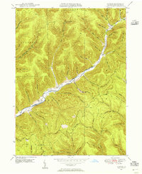
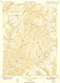
 1947 Conrad1952 Print · USGSPotter County’s timbered ridges and deep hollows are captured here just after the war, showing a rural landscape before modern development. Researchers can locate family cemeteries like Angell Cem and Reed Cem, or trace the old Jersey Shore Turnpike.4 unique versions available
 - 1947 Map of Conrad, 1956 Print
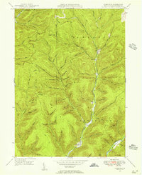
 1947 Conrad1956 Print · USGSPotter County’s deep valleys and timberlands are captured here in the mid-1940s as industry and nature intersected. Genealogists and hikers can trace old homesteads near Conrad, find the McFall Cem, and follow the historic Hammersley Trail.5 unique versions available
 - 1947 Map of Short Run, 1956 Print
 1947 Short Run1956 Print · USGSPotter County’s timbered ridges and deep hollows are documented here just after the war, showing the remote township corners and mountain trails. Trace family-named landmarks like Knickerbocker Hol and Yochum Run or find the early paths at Short Run.2 unique versions available
 - 1947 Map of Ayers Hill, 1957 Print
 1947 Ayers Hill1957 Print · USGSPotter County’s high ridges and deep hollows are captured here just after the war, showing a landscape defined by old family settlements and emerging recreation. Genealogists and hikers can trace early routes like the Coudersport Jersey Shore Turnpike or locate family sites like Anson Cem and the United Brethren Ch.3 unique versions available
 - 1947 Map of Cherry Springs, 1958 Print
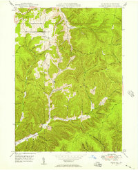
 1947 Cherry Springs1958 Print · USGSPotter County's forested ridges and deep hollows are captured here just after the war, showing a landscape defined by timber, transit, and conservation. Genealogists and hikers can trace the Coudersport Pike to Corbett or locate landmarks like Lyman Run Camp and the Cherry Springs Fire Tower.2 unique versions available
 - 1949 Map of Ayers Hill
 1949 Ayers Hill1949 Print · USGSPotter County’s wooded highlands appear here just after the war, showing the network of rural mountain roads and small hollows that shaped local life. Genealogists can locate family landmarks like Ayers Hill Cem, Borie, and the United Brethren Ch.2 unique versions available
 - 1949 Map of Short Run
 1949 Short Run1949 Print · USGSPotter County’s high plateaus and steep hollows are caught in fine detail during the late 1940s as forest roads began replacing old upland paths. Researchers can trace historic routes like the Splash Dam Trail and locate family-named landmarks such as Knickerbocker Hol and Bunnell Ridge.
 - 1949 Map of Cherry Springs
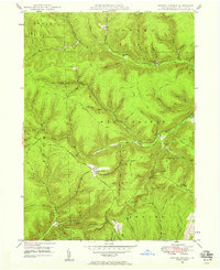
 1949 Cherry Springs1949 Print · USGSPotter County’s high plateaus and deep hollows are captured here in the late 1940s, showing a landscape shaped by forestry and early aviation. Genealogists and historians can trace old homesteads and landmarks like Lyman Run Camp, Mount Brodhead, and the Cherry Springs Fire Tower.
End of results
Showing maps 1-8 of 8
Top cities near Summit Township
- Roulette Township historical maps
- Sweden Township historical maps
- Ulysses historical maps
- Hebron Township historical maps
- Austin historical maps
- Hector Township historical maps
See more
Top neighborhoods of Summit Township
Frequently asked questions
- What are the different types of historical maps available for Summit Township?
- What is the oldest map of Summit Township?
- Where can I purchase historical maps of Summit Township for my home or office?
- Where can I download high-res historical maps of Summit Township?
- Are there historical topographic maps available for Summit Township?
- Is there historical aerial imagery available for Summit Township?
- Where are historical maps of Summit Township sourced from?