1950s Maps of Ulysses Township, Pennsylvania
Explore 2 historic maps of Ulysses Township from the 1950s. These maps offer a rare glimpse into what life looked like during the 1950s — showing old roads, neighborhoods, homes, and landmarks that have changed or disappeared over time.
Whether you're researching your family's past, planning a metal detecting trip, or studying how Ulysses Township's landscape evolved across the 1950s, these high-resolution maps are a powerful tool for exploring the history of this region.
- Focus on a specific era: All maps on this page are from the 1950s, giving you a focused view of this time period.
- See what’s changed: Compare century-old streets, trails, and buildings to today's modern landscape using overlays and satellite layers.
- Research with precision: Use these maps for genealogy, historical research, land use analysis, or educational projects.
- View, download, or print: Maps are fully viewable online in high resolution, and can be downloaded or printed for your own records.
Start exploring Ulysses Township's history through authentic maps from the 1950s. This is your window into the past.
Ulysses Township, PA maps
(2)- 1954 Map of Williamsport
 1954 Williamsport1954 Print · USGSNorth-central Pennsylvania in the mid-fifties is defined by the winding West Branch Susquehanna River and its industrial valley. Local historians can trace the massive Susquehanna Ordnance Depot and the extensive rail networks of the Pennsylvania Railroad.
 - 1957 Map of Harrison Valley, 1958 Print
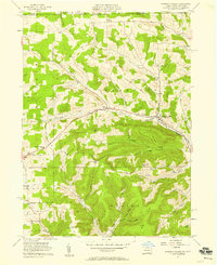 1957 Harrison Valley1958 Print · USGSPotter County communities along the Cowanesque River are documented here in the late fifties as the regional landscape transitioned from its rail-heavy past. Local researchers can trace family landmarks like Schofield Cem, the Northern Tier Childrens Home, and the OLD RAILROAD GRADE.3 unique versions available
End of results
Showing maps 1-2 of 2
Top cities near Ulysses Township
- Willing historical maps
- Galeton historical maps
- Independence historical maps
- Harrison Township historical maps
- Troupsburg historical maps
- Alma historical maps
See more
Top neighborhoods of Ulysses Township
- Walton historical maps
- Newfield Junction historical maps
- Newfield historical maps
- Brookland historical maps
- Fox Hill historical maps
- Gold historical maps
See more
Frequently asked questions
- What are the different types of historical maps available for Ulysses Township?
- What is the oldest map of Ulysses Township?
- Where can I purchase historical maps of Ulysses Township for my home or office?
- Where can I download high-res historical maps of Ulysses Township?
- Are there historical topographic maps available for Ulysses Township?
- Is there historical aerial imagery available for Ulysses Township?
- Where are historical maps of Ulysses Township sourced from?