2020s Maps of Ulysses Township, Pennsylvania
Explore 6 historic maps of Ulysses Township from the 2020s. These maps offer a rare glimpse into what life looked like during the 2020s — showing old roads, neighborhoods, homes, and landmarks that have changed or disappeared over time.
Whether you're researching your family's past, planning a metal detecting trip, or studying how Ulysses Township's landscape evolved across the 2020s, these high-resolution maps are a powerful tool for exploring the history of this region.
- Focus on a specific era: All maps on this page are from the 2020s, giving you a focused view of this time period.
- See what’s changed: Compare century-old streets, trails, and buildings to today's modern landscape using overlays and satellite layers.
- Research with precision: Use these maps for genealogy, historical research, land use analysis, or educational projects.
- View, download, or print: Maps are fully viewable online in high resolution, and can be downloaded or printed for your own records.
Start exploring Ulysses Township's history through authentic maps from the 2020s. This is your window into the past.
Ulysses Township, PA maps
(6)- 2023 Map of Harrison Valley, 2023 Print
 2023 Harrison Valley2023 Print · USGSHarrison Valley and the high ridges of Potter County are mapped here just south of the New York state line. Researchers can trace rural lineages through the English Family Cem, locate the small settlement of Mills, and follow the headwaters of the Genesee River.
 - 2023 Map of Cherry Springs, 2023 Print
 2023 Cherry Springs2023 Print · USGSPotter County in the early twenty-first century is characterized by deep forest hollows and small mountain hamlets. Genealogists and hikers can trace old routes to Corbett, Mount Brodhead, and family-named features like Jacob Hollow.
 - 2023 Map of West Pike, 2023 Print
 2023 West Pike2023 Print · USGSThe northern Pennsylvania highlands near West Pike are captured here in the early twenty-first century, showing a landscape of deep hollows and high ridges. Genealogists and hikers can trace the paths of Pine Creek, locate West Pike Cem, and follow the Susquehannock State Forest Snowmobile Trails Trl.
 - 2023 Map of Brookland, 2023 Print
 2023 Brookland2023 Print · USGSPotter County's high plateaus and deep hollows are captured here in the early twenty-first century, showing a landscape of small settlements and forest trails. Researchers can locate ancestral sites at All Saints Episcopal Church Cem, Raymond Cem, and the high-elevation community of Gold.
 - 2023 Map of Ulysses, 2023 Print
 2023 Ulysses2023 Print · USGSPotter County hill country in the twenty-first century reveals a landscape of isolated villages and family burial grounds. Researchers can trace the rural layout of Ulysses, Newfield, and Bingham Center or locate the Old Lewisville Cem.
 - 2023 Map of Galeton, 2023 Print
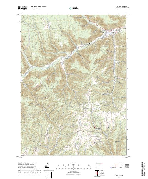 2023 Galeton2023 Print · USGSPotter County's rugged plateau is captured here in the modern era, centered on the historic river town of Galeton. Genealogists can locate family burial sites at Hurd Cem and Saint Germain Cem or trace the remote settlement at Burrows.
End of results
Showing maps 1-6 of 6
Top cities near Ulysses Township
- Willing historical maps
- Galeton historical maps
- Independence historical maps
- Harrison Township historical maps
- Troupsburg historical maps
- Alma historical maps
See more
Top neighborhoods of Ulysses Township
- Walton historical maps
- Newfield Junction historical maps
- Newfield historical maps
- Brookland historical maps
- Fox Hill historical maps
- Gold historical maps
See more
Frequently asked questions
- What are the different types of historical maps available for Ulysses Township?
- What is the oldest map of Ulysses Township?
- Where can I purchase historical maps of Ulysses Township for my home or office?
- Where can I download high-res historical maps of Ulysses Township?
- Are there historical topographic maps available for Ulysses Township?
- Is there historical aerial imagery available for Ulysses Township?
- Where are historical maps of Ulysses Township sourced from?