1990s Maps of Ulysses Township, Pennsylvania
Explore 2 historic maps of Ulysses Township from the 1990s. These maps offer a rare glimpse into what life looked like during the 1990s — showing old roads, neighborhoods, homes, and landmarks that have changed or disappeared over time.
Whether you're researching your family's past, planning a metal detecting trip, or studying how Ulysses Township's landscape evolved across the 1990s, these high-resolution maps are a powerful tool for exploring the history of this region.
- Focus on a specific era: All maps on this page are from the 1990s, giving you a focused view of this time period.
- See what’s changed: Compare century-old streets, trails, and buildings to today's modern landscape using overlays and satellite layers.
- Research with precision: Use these maps for genealogy, historical research, land use analysis, or educational projects.
- View, download, or print: Maps are fully viewable online in high resolution, and can be downloaded or printed for your own records.
Start exploring Ulysses Township's history through authentic maps from the 1990s. This is your window into the past.
Ulysses Township, PA maps
(2)- 1994 Map of Galeton, 1995 Print
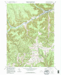 1994 Galeton1995 Print · USGSThe Potter County highlands near the end of the twentieth century remain a landscape of deep hollows and isolated hamlets. Genealogists and local historians can trace family locations at West Hill Cem, Germania, and the remote Carter Camp settlement.
 - 1994 Map of Cherry Springs, 1999 Print
 1994 Cherry Springs1999 Print · USGSPotter County’s high plateaus are shown in the 1990s as a haven for conservation and mountain recreation within the Susquehannock State Forest. Trace historical paths and forest infrastructure like the Cherry Springs Fire Tower, the Railroad Trail, and Lyman Run Camp.
End of results
Showing maps 1-2 of 2
Top cities near Ulysses Township
- Willing historical maps
- Galeton historical maps
- Independence historical maps
- Harrison Township historical maps
- Troupsburg historical maps
- Alma historical maps
See more
Top neighborhoods of Ulysses Township
- Walton historical maps
- Newfield Junction historical maps
- Newfield historical maps
- Brookland historical maps
- Fox Hill historical maps
- Gold historical maps
See more
Frequently asked questions
- What are the different types of historical maps available for Ulysses Township?
- What is the oldest map of Ulysses Township?
- Where can I purchase historical maps of Ulysses Township for my home or office?
- Where can I download high-res historical maps of Ulysses Township?
- Are there historical topographic maps available for Ulysses Township?
- Is there historical aerial imagery available for Ulysses Township?
- Where are historical maps of Ulysses Township sourced from?