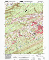
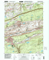
1900s (20th Century) Maps of Butler Township, Pennsylvania
Explore 25 historic maps of Butler Township from the 1900s (20th Century). These maps offer a rare glimpse into what life looked like during the 1900s — showing old roads, neighborhoods, homes, and landmarks that have changed or disappeared over time.
Whether you're researching your family's past, planning a metal detecting trip, or studying how Butler Township's landscape evolved across the 1900s, these high-resolution maps are a powerful tool for exploring the history of this region.
- Focus on a specific era: All maps on this page are from the 1900s, giving you a focused view of this time period.
- See what’s changed: Compare century-old streets, trails, and buildings to today's modern landscape using overlays and satellite layers.
- Research with precision: Use these maps for genealogy, historical research, land use analysis, or educational projects.
- View, download, or print: Maps are fully viewable online in high resolution, and can be downloaded or printed for your own records.
Start exploring Butler Township's history through authentic maps from the 1900s. This is your window into the past.
Butler Township, PA maps
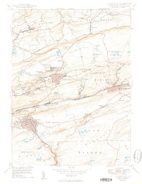
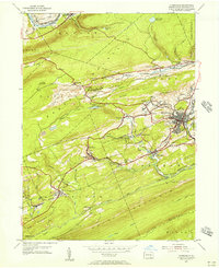
(25)- 1947 Map of Ashland
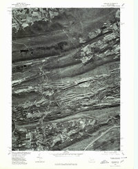
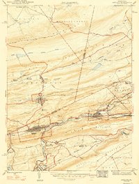 1947 Ashland1947 Print · USGSAnthracite coal country comes into sharp focus during the mid-1940s as the valley towns of Schuylkill and Columbia counties reach their peak development. Genealogists and researchers can trace the street grids of Ashland, find the Miners Hospital, and locate Centralia years before its famous underground fires.3 unique versions available
 - 1947 Map of Mt. Carmel
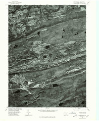
 1947 Mt. Carmel1947 Print · USGSThe Pennsylvania coal region is shown here at its post-war industrial peak, bounded by the ridges of Big Mountain and Locust Mountain. Genealogists and historians can trace the intricate rail networks and compact neighborhoods of Mount Carmel, Kulpmont, and Locust Summit.2 unique versions available
 - 1947 Map of Minersville
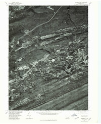
 1947 Minersville1947 Print · USGSAnthracite coal mining and rail infrastructure define this mid-century look at the Schuylkill County landscape. Genealogists and historians can trace the detailed street grids of Minersville and find smaller coal settlements like Heckscherville, New Mines, and Coal Castle.2 unique versions available
 - 1947 Map of Tremont
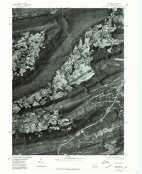
 1947 Tremont1947 Print · USGSSchuylkill County is shown here in the late 1940s, where rail lines and mountain ridges dictate the flow of local life. Researchers can trace the Reading railroad corridor through Tremont or locate rural landmarks like Salem Ch and Beury Lake.2 unique versions available
 - 1950 Map of Shenandoah
 1950 Shenandoah1950 Print · USGSSchuylkill County’s coal heartland is revealed at its mid-century peak, showing the dense rail and mining infrastructure of the anthracite region. Genealogy researchers can trace family sites from Shenandoah to Mahanoy City, locating landmarks like The Peddlars Grave and Old White Ch.2 unique versions available
 - 1950 Map of Harrisburg, 1952 Print
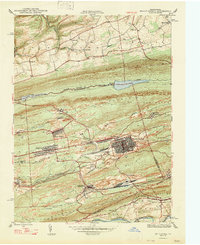
 1950 Harrisburg1952 Print · USGSMid-century Central Pennsylvania comes alive through its dense rail networks and river valley settlements during the post-war industrial era. Genealogists and historians can trace family roots through hubs like Harrisburg, locate Carlisle Barracks, or follow the Pennsylvania RR through the Lebanon Valley.
 - 1953 Map of Ashland, 1956 Print
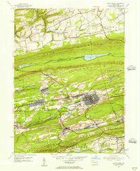
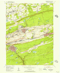
 1953 Ashland1956 Print · USGSIn the 1950s, the anthracite coal region around Ashland and Girardville was at its industrial peak. Genealogists can trace family homes in Centralia or Gordon and locate landmarks like Immaculate Heart Academy or the Centralia Fire Tower.5 unique versions available
 - 1954 Map of Tremont, 1956 Print
 1954 Tremont1956 Print · USGSSchuylkill County in the mid-fifties shows a landscape defined by the anthracite valleys and the parallel ridges of the Appalachians. Researchers can trace the READING rail lines through Tremont and Donaldson, or locate family landmarks like Salem Ch and Klingers Sch.4 unique versions available
 - 1955 Map of Mount Carmel, 1956 Print
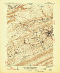
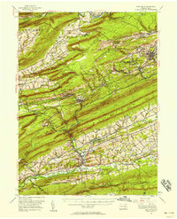
 1955 Mount Carmel1956 Print · USGSNorthumberland County's coal-country landscape is meticulously detailed here in the mid-fifties, showing the rail-dependent corridor between Kulpmont and Mount Carmel. Genealogists and historians can trace the foundations of local life through the Township Sch, Mount Carmel Cemetery, and the Drive-in Theater at Natalie.5 unique versions available
 - 1955 Map of Minersville, 1956 Print
 1955 Minersville1956 Print · USGSSchuylkill County mining towns thrive amidst the ridges of the anthracite coal region in the mid-1950s. Genealogists and industrial historians can trace the intricate rail lines of the Reading and find vanished local landmarks like Triedens Ch and New Mines.6 unique versions available
 - 1955 Map of Shenandoah, 1956 Print
 1955 Shenandoah1956 Print · USGSAnthracite coal country comes alive in the mid-fifties, showing the dense rail networks and industrial settlements of the Schuylkill valley. Trace family roots in Shenandoah or Mahanoy City, and locate landmarks like Old White Ch and the Incline.5 unique versions available
 - 1955 Map of Pine Grove, 1958 Print
 1955 Pine Grove1958 Print · USGSSchuylkill County coal towns and the Blue Mountain ridges are documented here in the mid-1950s. Genealogists and researchers can locate family-named landmarks like Klingers Sch and Hauer Ch alongside coal-era infrastructure like Coal Castle.3 unique versions available
 - 1955 Map of Catawissa, 1960 Print
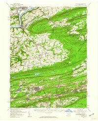 1955 Catawissa1960 Print · USGSThe coal and river valleys of Columbia and Schuylkill counties are shown here in the mid-1950s. Genealogists and historians can trace family roots through numerous sites like Centralia, St Marys Cem, and Parrs Mill.2 unique versions available
 - 1955 Map of Mahanoy, 1960 Print
 1955 Mahanoy1960 Print · USGSThe anthracite coalfields of Schuylkill County are shown in full industrial operation during the mid-1950s. Researchers can locate specific colliery sites and landmarks like Harwood, the Mahanoy Tunnel, and the lone Peddlars Grave.
 - 1957 Map of Harrisburg
 1957 Harrisburg1957 Print · USGSMid-century Central Pennsylvania comes into focus as a bustling network of rail, river, and mountain ridges. Genealogists and historians can trace the development of the State Capitol and surrounding hubs like Middletown, Columbia, and Pottsville.7 unique versions available
 - 1961 Map of Harrisburg
 1961 Harrisburg1961 Print · USGSCentral Pennsylvania is shown at a mid-century peak of industrial and military activity, from the Susquehanna water gaps to the fertile Dutch Country. Genealogists and historians can trace the rail corridors of the Pennsylvania RR and find landmarks like Carlisle Barracks or the Anthracite Coal Fields.2 unique versions available
 - 1964 Map of Harrisburg
 1964 Harrisburg1964 Print · USGSCentral Pennsylvania in the mid-fifties reveals a landscape shaped by ridge-and-valley geology and critical Cold War infrastructure. Researchers can trace the massive Indiantown Gap Military Reservation or the rail corridors of the Pennsylvania RR and Reading RR.
 - 1976 Map of Ashland, 1979 Print
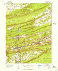
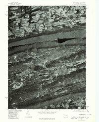
 1976 Ashland1979 Print · USGSThe anthracite coal region of Schuylkill County is seen here in the late seventies through detailed aerial orthophotography. Researchers can trace the street grids and industrial footprints of Centralia, Girardville, and Gordon against the ridges of Broad Mountain.
 - 1976 Map of Shenandoah, 1979 Print
 1976 Shenandoah1979 Print · USGSThe anthracite region of Schuylkill County is seen in the mid-seventies through detailed aerial imagery. Trace the industrial footprint and neighborhood grids of Shenandoah, Mahanoy City, and Frackville as they appeared decades ago.
 - 1976 Map of Minersville, 1979 Print
 1976 Minersville1979 Print · USGSThe Southern Anthracite Field comes into sharp focus during the mid-seventies, showing the physical footprint of Pennsylvania coal country. Genealogists and local historians can trace the residential layouts of Minersville and Llewellyn against the backdrop of Broad Mountain.
 - 1977 Map of Tremont, 1979 Print
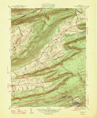
 1977 Tremont1979 Print · USGSSchuylkill County's ridge-and-valley landscape is captured in the late seventies through detailed aerial imagery. Trace the development of valley settlements like Hegins and Donaldson alongside the industrial corridors of Broad Mountain.
 - 1977 Map of Mount Carmel, 1979 Print
 1977 Mount Carmel1979 Print · USGSMount Carmel and the anthracite coal region appear here in the late seventies, captured in detailed aerial imagery. Genealogists and historians can trace the gridded streets of Mount Carmel, Kulpmont, and Locust Gap against the ridges of Big Mountain.
 - 1984 Map of Sunbury, 1985 Print
 1984 Sunbury1985 Print · USGSPennsylvania coal country and the Susquehanna valley appear here in the early eighties, showcasing a landscape defined by industrial ridges and river towns. Genealogists and historians can trace rail corridors like Conrail and explore mountain settlements from Mahanoy City to Elizabethville.2 unique versions available
 - 1999 Map of Minersville, 2001 Print
 1999 Minersville2001 Print · USGSSchuylkill County coal country comes into sharp focus at the end of the century as industrial valleys meet the high ridges of the Appalachians. Genealogists and historians can trace family-named sites and vanished industrial works from Minersville to New Mines and Coal Castle.
 - 1999 Map of Shenandoah, 2002 Print
 1999 Shenandoah2002 Print · USGSSchuylkill County's coal-mining heartland is captured here at the end of the twentieth century, showing the dense urban grid of SHENANDOAH set against the industrial ridges. Researchers can trace the heritage of colliery life at Morea or find family landmarks like Peddlars Grave and Old White Ch.
End of results
Showing maps 1-25 of 25
Top cities near Butler Township
- Bloomsburg historical maps
- Pottsville historical maps
- Shamokin historical maps
- Mount Carmel historical maps
- Shenandoah historical maps
- Schuylkill Haven historical maps
See more
Top neighborhoods of Butler Township
- Mowry historical maps
- Englewood historical maps
- Big Mine Run historical maps
- Connerton historical maps
- Helfenstein historical maps
- Preston Hill historical maps
See more
Frequently asked questions
- What are the different types of historical maps available for Butler Township?
- What is the oldest map of Butler Township?
- Where can I purchase historical maps of Butler Township for my home or office?
- Where can I download high-res historical maps of Butler Township?
- Are there historical topographic maps available for Butler Township?
- Is there historical aerial imagery available for Butler Township?
- Where are historical maps of Butler Township sourced from?