1970s Maps of Butler Township, Pennsylvania
Explore 5 historic maps of Butler Township from the 1970s. These maps offer a rare glimpse into what life looked like during the 1970s — showing old roads, neighborhoods, homes, and landmarks that have changed or disappeared over time.
Whether you're researching your family's past, planning a metal detecting trip, or studying how Butler Township's landscape evolved across the 1970s, these high-resolution maps are a powerful tool for exploring the history of this region.
- Focus on a specific era: All maps on this page are from the 1970s, giving you a focused view of this time period.
- See what’s changed: Compare century-old streets, trails, and buildings to today's modern landscape using overlays and satellite layers.
- Research with precision: Use these maps for genealogy, historical research, land use analysis, or educational projects.
- View, download, or print: Maps are fully viewable online in high resolution, and can be downloaded or printed for your own records.
Start exploring Butler Township's history through authentic maps from the 1970s. This is your window into the past.
Butler Township, PA maps
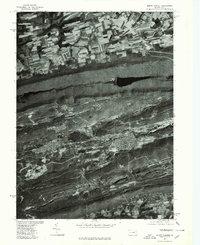
(5)- 1976 Map of Ashland, 1979 Print
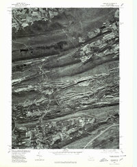 1976 Ashland1979 Print · USGSThe anthracite coal region of Schuylkill County is seen here in the late seventies through detailed aerial orthophotography. Researchers can trace the street grids and industrial footprints of Centralia, Girardville, and Gordon against the ridges of Broad Mountain.
 - 1976 Map of Shenandoah, 1979 Print
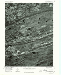 1976 Shenandoah1979 Print · USGSThe anthracite region of Schuylkill County is seen in the mid-seventies through detailed aerial imagery. Trace the industrial footprint and neighborhood grids of Shenandoah, Mahanoy City, and Frackville as they appeared decades ago.
 - 1976 Map of Minersville, 1979 Print
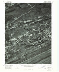 1976 Minersville1979 Print · USGSThe Southern Anthracite Field comes into sharp focus during the mid-seventies, showing the physical footprint of Pennsylvania coal country. Genealogists and local historians can trace the residential layouts of Minersville and Llewellyn against the backdrop of Broad Mountain.
 - 1977 Map of Tremont, 1979 Print
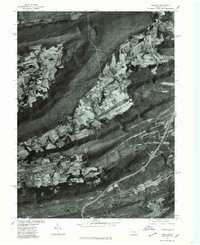 1977 Tremont1979 Print · USGSSchuylkill County's ridge-and-valley landscape is captured in the late seventies through detailed aerial imagery. Trace the development of valley settlements like Hegins and Donaldson alongside the industrial corridors of Broad Mountain.
 - 1977 Map of Mount Carmel, 1979 Print
 1977 Mount Carmel1979 Print · USGSMount Carmel and the anthracite coal region appear here in the late seventies, captured in detailed aerial imagery. Genealogists and historians can trace the gridded streets of Mount Carmel, Kulpmont, and Locust Gap against the ridges of Big Mountain.
End of results
Showing maps 1-5 of 5
Top cities near Butler Township
- Bloomsburg historical maps
- Pottsville historical maps
- Shamokin historical maps
- Mount Carmel historical maps
- Shenandoah historical maps
- Schuylkill Haven historical maps
See more
Top neighborhoods of Butler Township
- Mowry historical maps
- Englewood historical maps
- Big Mine Run historical maps
- Connerton historical maps
- Helfenstein historical maps
- Preston Hill historical maps
See more
Frequently asked questions
- What are the different types of historical maps available for Butler Township?
- What is the oldest map of Butler Township?
- Where can I purchase historical maps of Butler Township for my home or office?
- Where can I download high-res historical maps of Butler Township?
- Are there historical topographic maps available for Butler Township?
- Is there historical aerial imagery available for Butler Township?
- Where are historical maps of Butler Township sourced from?