1990s Maps of Heckscherville, Cass Township
Explore 2 historic maps of Heckscherville from the 1990s. These maps offer a rare glimpse into what life looked like during the 1990s — showing old roads, neighborhoods, homes, and landmarks that have changed or disappeared over time.
Whether you're researching your family's past, planning a metal detecting trip, or studying how Heckscherville's landscape evolved across the 1990s, these high-resolution maps are a powerful tool for exploring the history of this region.
- Focus on a specific era: All maps on this page are from the 1990s, giving you a focused view of this time period.
- See what’s changed: Compare century-old streets, trails, and buildings to today's modern landscape using overlays and satellite layers.
- Research with precision: Use these maps for genealogy, historical research, land use analysis, or educational projects.
- View, download, or print: Maps are fully viewable online in high resolution, and can be downloaded or printed for your own records.
Start exploring Heckscherville's history through authentic maps from the 1990s. This is your window into the past.
Heckscherville, Cass Township maps
(2)- 1994 Map of Pottsville, 1995 Print
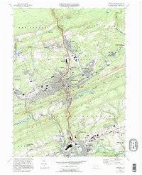 1994 Pottsville1995 Print · USGSSchuylkill County at the end of the twentieth century shows a landscape shaped by coal and industry. Researchers can trace family roots through the German Cem, locate the Penn State University campus, and see the extent of strip mines near St Clair.
 - 1999 Map of Minersville, 2001 Print
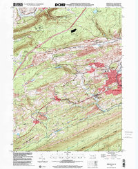 1999 Minersville2001 Print · USGSSchuylkill County coal country comes into sharp focus at the end of the century as industrial valleys meet the high ridges of the Appalachians. Genealogists and historians can trace family-named sites and vanished industrial works from Minersville to New Mines and Coal Castle.
End of results
Showing maps 1-2 of 2
Top cities near Heckscherville
- Pottsville historical maps
- Mount Carmel historical maps
- Shenandoah historical maps
- Schuylkill Haven historical maps
- Bethel Township historical maps
- Mahanoy City historical maps
See more
Frequently asked questions
- What are the different types of historical maps available for Heckscherville?
- What is the oldest map of Heckscherville?
- Where can I purchase historical maps of Heckscherville for my home or office?
- Where can I download high-res historical maps of Heckscherville?
- Are there historical topographic maps available for Heckscherville?
- Is there historical aerial imagery available for Heckscherville?
- Where are historical maps of Heckscherville sourced from?