1940s Maps of Wayne Township, Pennsylvania
Explore 5 historic maps of Wayne Township from the 1940s. These maps offer a rare glimpse into what life looked like during the 1940s — showing old roads, neighborhoods, homes, and landmarks that have changed or disappeared over time.
Whether you're researching your family's past, planning a metal detecting trip, or studying how Wayne Township's landscape evolved across the 1940s, these high-resolution maps are a powerful tool for exploring the history of this region.
- Focus on a specific era: All maps on this page are from the 1940s, giving you a focused view of this time period.
- See what’s changed: Compare century-old streets, trails, and buildings to today's modern landscape using overlays and satellite layers.
- Research with precision: Use these maps for genealogy, historical research, land use analysis, or educational projects.
- View, download, or print: Maps are fully viewable online in high resolution, and can be downloaded or printed for your own records.
Start exploring Wayne Township's history through authentic maps from the 1940s. This is your window into the past.
Wayne Township, PA maps
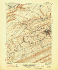
(5)- 1944 Map of Pottsville
 1944 Pottsville1944 Print · USGSThe anthracite region of Pennsylvania shows its industrial density during the 1940s, with coal-dependent settlements lining the mountain valleys. Genealogists and historians can trace the rail networks of the Reading and Lehigh lines through Pottsville, St Clair, and East Mines.10 unique versions available
 - 1945 Map of Friedensburg, 1958 Print
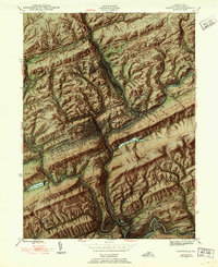
 1945 Friedensburg1958 Print · USGSSchuylkill County at the end of the war is a landscape of valley townships and ridge-top trails. Genealogists can trace a dense network of rural schools and villages like Friedensburg, Summit Station, and Brommerstown, alongside the early route of the Appalachian Trail.7 unique versions available
 - 1946 Map of Friedensburg
 1946 Friedensburg1946 Print · USGSSchuylkill and Berks counties appear here shortly after the war, showing the mountain ridges and valley towns of the mid-1940s. Trace local family history at Friedensburg, old rural schools like Panther Valley Sch, or the path of the Appalachian Trail.2 unique versions available
 - 1946 Map of Swatara Hill
 1946 Swatara Hill1946 Print · USGSSchuylkill and Berks counties are shown in the 1940s as a landscape of ridge-and-valley farming and early mountain recreation. Genealogists can locate family landmarks like Manbeck Cem or tracing historic schoolhouses such as Kershner Sch and Fidler Sch.2 unique versions available
 - 1947 Map of Minersville
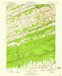
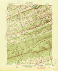
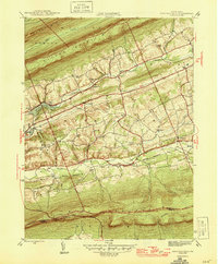
 1947 Minersville1947 Print · USGSAnthracite coal mining and rail infrastructure define this mid-century look at the Schuylkill County landscape. Genealogists and historians can trace the detailed street grids of Minersville and find smaller coal settlements like Heckscherville, New Mines, and Coal Castle.2 unique versions available
End of results
Showing maps 1-5 of 5
Top cities near Wayne Township
- Pottsville historical maps
- Mount Carmel historical maps
- Schuylkill Haven historical maps
- Bethel Township historical maps
- Minersville historical maps
- Frackville historical maps
See more
Top neighborhoods of Wayne Township
- Reedsville historical maps
- Summit Station historical maps
- Roeders historical maps
- Roeders historical maps
- Moyers historical maps
- Stonemont historical maps
See more
Frequently asked questions
- What are the different types of historical maps available for Wayne Township?
- What is the oldest map of Wayne Township?
- Where can I purchase historical maps of Wayne Township for my home or office?
- Where can I download high-res historical maps of Wayne Township?
- Are there historical topographic maps available for Wayne Township?
- Is there historical aerial imagery available for Wayne Township?
- Where are historical maps of Wayne Township sourced from?