1990s Maps of Quemahoning Township, Pennsylvania
Explore 2 historic maps of Quemahoning Township from the 1990s. These maps offer a rare glimpse into what life looked like during the 1990s — showing old roads, neighborhoods, homes, and landmarks that have changed or disappeared over time.
Whether you're researching your family's past, planning a metal detecting trip, or studying how Quemahoning Township's landscape evolved across the 1990s, these high-resolution maps are a powerful tool for exploring the history of this region.
- Focus on a specific era: All maps on this page are from the 1990s, giving you a focused view of this time period.
- See what’s changed: Compare century-old streets, trails, and buildings to today's modern landscape using overlays and satellite layers.
- Research with precision: Use these maps for genealogy, historical research, land use analysis, or educational projects.
- View, download, or print: Maps are fully viewable online in high resolution, and can be downloaded or printed for your own records.
Start exploring Quemahoning Township's history through authentic maps from the 1990s. This is your window into the past.
Quemahoning Township, PA maps
(2)- 1994 Map of Stoystown, 1999 Print
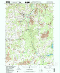 1994 Stoystown1999 Print · USGSSomerset County in the mid-1990s shows a landscape defined by the Stonycreek River and the legacy of the regional coal industry. Researchers can find old landmarks like the Walker Cem, the Rayman Ch, and a Covered Bridge near Shanksville.2 unique versions available
 - 1997 Map of Boswell, 2000 Print
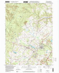 1997 Boswell2000 Print · USGSSomerset County coal towns and the ridges of the Laurel Highlands are captured here in the late nineties as the landscape shifted from active extraction to reclamation. Genealogists and researchers can locate family sites at SS Peter and Paul Cem, Klines Mill, and the settlement of Jenners Crossroads.
End of results
Showing maps 1-2 of 2
Top cities near Quemahoning Township
- Johnstown historical maps
- Somerset historical maps
- Franklin historical maps
- Westmont historical maps
- Windber historical maps
- Stonycreek Township historical maps
See more
Top neighborhoods of Quemahoning Township
- Kantner historical maps
- Mostoller historical maps
- Ralphton historical maps
- Reading Number Three historical maps
- Kimmelton historical maps
Frequently asked questions
- What are the different types of historical maps available for Quemahoning Township?
- What is the oldest map of Quemahoning Township?
- Where can I purchase historical maps of Quemahoning Township for my home or office?
- Where can I download high-res historical maps of Quemahoning Township?
- Are there historical topographic maps available for Quemahoning Township?
- Is there historical aerial imagery available for Quemahoning Township?
- Where are historical maps of Quemahoning Township sourced from?