1930s Maps of Laurel Falls, Summit Township
Explore 1 historic maps of Laurel Falls from the 1930s. These maps offer a rare glimpse into what life looked like during the 1930s — showing old roads, neighborhoods, homes, and landmarks that have changed or disappeared over time.
Whether you're researching your family's past, planning a metal detecting trip, or studying how Laurel Falls's landscape evolved across the 1930s, these high-resolution maps are a powerful tool for exploring the history of this region.
- Focus on a specific era: All maps on this page are from the 1930s, giving you a focused view of this time period.
- See what’s changed: Compare century-old streets, trails, and buildings to today's modern landscape using overlays and satellite layers.
- Research with precision: Use these maps for genealogy, historical research, land use analysis, or educational projects.
- View, download, or print: Maps are fully viewable online in high resolution, and can be downloaded or printed for your own records.
Start exploring Laurel Falls's history through authentic maps from the 1930s. This is your window into the past.
Laurel Falls, Summit Township maps
(1)- 1939 Map of Meyersdale, 1955 Print
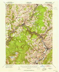 1939 Meyersdale1955 Print · USGSSomerset County is captured here in the late 1930s, showing a landscape defined by the winding Casselman River and its coal-bearing valleys. Local historians can trace the reach of the Baltimore and Ohio Railroad past dozens of rural landmarks like Comptons Mill and Mt Davis.2 unique versions available
End of results
Showing maps 1-1 of 1
Top cities near Laurel Falls
- Frostburg historical maps
- Somerset historical maps
- Meyersdale historical maps
- Berlin historical maps
- Milford historical maps
- Eckhart Mines historical maps
See more
Frequently asked questions
- What are the different types of historical maps available for Laurel Falls?
- What is the oldest map of Laurel Falls?
- Where can I purchase historical maps of Laurel Falls for my home or office?
- Where can I download high-res historical maps of Laurel Falls?
- Are there historical topographic maps available for Laurel Falls?
- Is there historical aerial imagery available for Laurel Falls?
- Where are historical maps of Laurel Falls sourced from?