1970s Maps of Sullivan County, Pennsylvania
Explore 5 historic maps of Sullivan County from the 1970s. These maps offer a rare glimpse into what life looked like during the 1970s — showing old roads, neighborhoods, homes, and landmarks that have changed or disappeared over time.
Whether you're researching your family's past, planning a metal detecting trip, or studying how Sullivan County's landscape evolved across the 1970s, these high-resolution maps are a powerful tool for exploring the history of this region.
- Focus on a specific era: All maps on this page are from the 1970s, giving you a focused view of this time period.
- See what’s changed: Compare century-old streets, trails, and buildings to today's modern landscape using overlays and satellite layers.
- Research with precision: Use these maps for genealogy, historical research, land use analysis, or educational projects.
- View, download, or print: Maps are fully viewable online in high resolution, and can be downloaded or printed for your own records.
Start exploring Sullivan County's history through authentic maps from the 1970s. This is your window into the past.
Sullivan County, PA maps
(5)- 1970 Map of Picture Rocks, 1973 Print
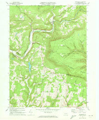
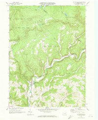 1970 Picture Rocks1973 Print · USGSThe Lycoming County highlands come into focus in the early seventies, centered on the mill-town origins of Picture Rocks and the winding Muncy Creek. Genealogists and researchers can trace rural homesteads near Tivoli, historic sites like Bryan Mill, and remote landmarks including Mapleton Ch.3 unique versions available
 - 1970 Map of Shunk, 1973 Print
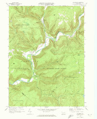
 1970 Shunk1973 Print · USGSSullivan and Bradford Counties are shown here during the early 1970s, a period of quiet rural life and expanding state forest conservation. Researchers can locate remote settlements like Shunk and Minerville, or find family landmarks such as the Elkland Meetinghouse and Camp Brule.3 unique versions available
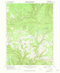
 - 1970 Map of Overton, 1973 Print
 1970 Overton1973 Print · USGSSullivan and Bradford counties in the early 1970s showcase a high-elevation world of remote crossroads and upland farms. Trace family roots and local history through rural anchors like Peters Ch, the Greenwood Cem, and the village of Campbellville.2 unique versions available
 - 1970 Map of Hillsgrove, 1973 Print
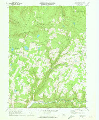
 1970 Hillsgrove1973 Print · USGSSullivan County’s high plateau country is captured here in the early seventies, showing the traditional mountain settlements and vast conservation lands. Researchers can trace historic crossings and landmarks like the Covered Bridge, Angel Falls, and the old forest hamlet of Ogdonia.
 - 1970 Map of Sonestown, 1973 Print
 1970 Sonestown1973 Print · USGSThe high ridges and deep hollows of Sullivan County are captured here during the 1970s, showcasing a landscape of mountain hamlets and forest preserves. Researchers can trace the Old Railroad Grade through Sonestown or locate rural landmarks like the Covered Bridge and Franklin Ch.3 unique versions available
End of results
Showing maps 1-5 of 5
Top cities of Sullivan County
- Colley Township historical maps
- Dushore historical maps
- Laporte historical maps
- Hillsgrove Township historical maps
- Eagles Mere historical maps
- Forksville historical maps
Frequently asked questions
- What are the different types of historical maps available for Sullivan County?
- What is the oldest map of Sullivan County?
- Where can I purchase historical maps of Sullivan County for my home or office?
- Where can I download high-res historical maps of Sullivan County?
- Are there historical topographic maps available for Sullivan County?
- Is there historical aerial imagery available for Sullivan County?
- Where are historical maps of Sullivan County sourced from?