2020s Maps of Ararat Township, Pennsylvania
Explore 2 historic maps of Ararat Township from the 2020s. These maps offer a rare glimpse into what life looked like during the 2020s — showing old roads, neighborhoods, homes, and landmarks that have changed or disappeared over time.
Whether you're researching your family's past, planning a metal detecting trip, or studying how Ararat Township's landscape evolved across the 2020s, these high-resolution maps are a powerful tool for exploring the history of this region.
- Focus on a specific era: All maps on this page are from the 2020s, giving you a focused view of this time period.
- See what’s changed: Compare century-old streets, trails, and buildings to today's modern landscape using overlays and satellite layers.
- Research with precision: Use these maps for genealogy, historical research, land use analysis, or educational projects.
- View, download, or print: Maps are fully viewable online in high resolution, and can be downloaded or printed for your own records.
Start exploring Ararat Township's history through authentic maps from the 2020s. This is your window into the past.
Ararat Township, PA maps
(2)- 2023 Map of Thompson, 2023 Print
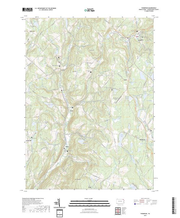 2023 Thompson2023 Print · USGSSusquehanna County’s highland landscape is documented here in the early twenty-first century, showing a region defined by its historic turnpikes and rail corridors. Researchers can trace ancestral roots through numerous burial sites like Saint Mary's Russian Cem or explore the route of the D&H Rail-Trl near Thompson.
 - 2023 Map of Orson, 2023 Print
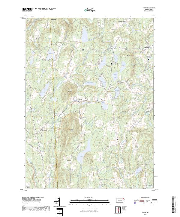 2023 Orson2023 Print · USGSWayne and Susquehanna counties are shown in the 2020s, a landscape defined by glacial lakes and the paths of old rail lines. Researchers can trace family history at the West Preston Cem or follow the historic rail grades of the O&W Rail-Trl and D&H Rail-Trl.
End of results
Showing maps 1-2 of 2
Top cities near Ararat Township
- Windsor historical maps
- Scott Township historical maps
- Hancock historical maps
- Clifford Township historical maps
- Sanford historical maps
- Lenox Township historical maps
See more
Top neighborhoods of Ararat Township
Frequently asked questions
- What are the different types of historical maps available for Ararat Township?
- What is the oldest map of Ararat Township?
- Where can I purchase historical maps of Ararat Township for my home or office?
- Where can I download high-res historical maps of Ararat Township?
- Are there historical topographic maps available for Ararat Township?
- Is there historical aerial imagery available for Ararat Township?
- Where are historical maps of Ararat Township sourced from?