1990s Maps of Middlebury Township, Pennsylvania
Explore 3 historic maps of Middlebury Township from the 1990s. These maps offer a rare glimpse into what life looked like during the 1990s — showing old roads, neighborhoods, homes, and landmarks that have changed or disappeared over time.
Whether you're researching your family's past, planning a metal detecting trip, or studying how Middlebury Township's landscape evolved across the 1990s, these high-resolution maps are a powerful tool for exploring the history of this region.
- Focus on a specific era: All maps on this page are from the 1990s, giving you a focused view of this time period.
- See what’s changed: Compare century-old streets, trails, and buildings to today's modern landscape using overlays and satellite layers.
- Research with precision: Use these maps for genealogy, historical research, land use analysis, or educational projects.
- View, download, or print: Maps are fully viewable online in high resolution, and can be downloaded or printed for your own records.
Start exploring Middlebury Township's history through authentic maps from the 1990s. This is your window into the past.
Middlebury Township, PA maps
(3)- 1994 Map of Keeneyville, 1998 Print
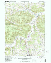 1994 Keeneyville1998 Print · USGSTioga County life in the late twentieth century is documented here along the winding valleys of Crooked Creek and Marsh Creek. Researchers can trace the legacy of small communities and rural institutions like the Catlin Hollow Ch and Niles Valley Cem.
 - 1994 Map of Crooked Creek, 1999 Print
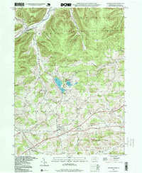 1994 Crooked Creek1999 Print · USGSTioga County's rural valleys and northern highlands are captured here in the late twentieth century, showing a landscape defined by state parks and small crossroads. Researchers can locate community anchors like Whitneyville, the Hills Creek Ch, and the Dartt Settlement Cem.
 - 1999 Map of Elkland, 2001 Print
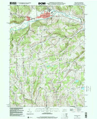 1999 Elkland2001 Print · USGSThe Cowanesque River valley at the New York border is shown here at the close of the twentieth century. Researchers can trace family roots through numerous highland burial grounds like Taylor Cem and rural centers such as Karls Corners and Farmington Ch.
End of results
Showing maps 1-3 of 3
Top cities near Middlebury Township
- Mansfield historical maps
- Wellsboro historical maps
- Caton historical maps
- Lindley historical maps
- Elkland historical maps
- Woodhull historical maps
See more
Top neighborhoods of Middlebury Township
- Hammond historical maps
- Keeneyville historical maps
- Niles Valley historical maps
- Shinglebury historical maps
- Crooked Creek historical maps
- Middlebury Center historical maps
Frequently asked questions
- What are the different types of historical maps available for Middlebury Township?
- What is the oldest map of Middlebury Township?
- Where can I purchase historical maps of Middlebury Township for my home or office?
- Where can I download high-res historical maps of Middlebury Township?
- Are there historical topographic maps available for Middlebury Township?
- Is there historical aerial imagery available for Middlebury Township?
- Where are historical maps of Middlebury Township sourced from?