Old Maps of Morris Township, Pennsylvania for Academic Research
Study the evolution of Morris Township with 33 high-resolution historic maps. Whether you're teaching, researching, or modeling changes in land use, these maps provide essential visual documentation of urban, environmental, and geographic change.
- Analyze long-term change: Track patterns in development, transportation, and natural features.
- Ideal for environmental or urban studies: Support academic projects with primary historical map data.
- Use in the classroom or lab: Educators and researchers rely on these maps to bring historical context to life.
These maps are a powerful tool for teaching, research, and visualizing how Morris Township has changed over the decades.
Morris Township, PA maps
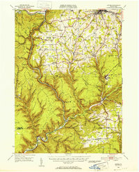
(33)- 1925 Map of Blossburg, 1958 Print
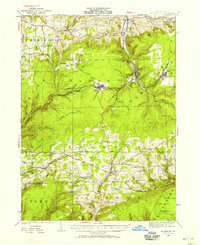 1925 Blossburg1958 Print · USGSTioga County’s coal and timber country is captured here during the 1920s, when the Tioga River and Erie R R drove the local economy. Researchers can locate dozens of country schoolhouses, rural churches like Burt Church, and early industrial sites such as Blacks Mill.2 unique versions available
 - 1927 Map of Blossburg
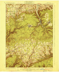 1927 Blossburg1927 Print · USGSTioga County's coal country and rural townships are captured here in the mid-1920s, showing the height of the mountain rail and mining era. Genealogists can locate family-named sites like Blacks Mill, Hart Church, and vanished schoolhouses such as Culver School.4 unique versions available
 - 1944 Map of Blossburg
 1944 Blossburg1944 Print · USGSTioga County during the mid-1940s reveals a landscape of industrial coal towns and remote ridge-top schoolhouses. Genealogists and historians can trace family roots through numerous local landmarks, including Blacks Mill, the Erie Railroad, and several rural sites like Nauvoo or Beuter School.
 - 1946 Map of Tiadaghton
 1946 Tiadaghton1946 Print · USGSTioga County's dramatic canyon country is captured here in the mid-1940s, showing the intersection of industry and rural life. Researchers can trace the New York Central line through Pine Creek Gorge or locate family landmarks like Olmsville Cem and the Middle Ridge Ch.5 unique versions available
 - 1946 Map of Antrim, 1952 Print
 1946 Antrim1952 Print · USGSTioga County in the years following World War II is defined by the deep carving of Pine Creek Gorge and a network of mountain railroads. Genealogists can trace family roots through remote sites like Antrim Cem, Heise Run Sch, and the Cedar Run Ch.2 unique versions available
 - 1946 Map of Cedar Run, 1956 Print
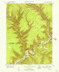 1946 Cedar Run1956 Print · USGSPine Creek Gorge and the rugged Tioga County highlands are captured here in the mid-1940s as the rail-and-river economy still shaped the valley. Researchers can trace family roots near Blackwell Lloyd PO, the Cedar Run Ch, and the remote settlement of Leetonia.4 unique versions available
 - 1946 Map of Antrim, 1963 Print
 1946 Antrim1963 Print · USGSTioga County in the mid-forties reflects a landscape of small upland settlements and valley railroads near the borough of Wellsboro. Researchers can trace the path of the New York Central rail line past Antrim and locate local landmarks like Heise Run Sch and the County Home.5 unique versions available
 - 1946 Map of Morris, 1965 Print
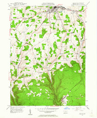
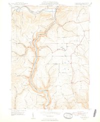
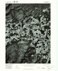
 1946 Morris1965 Print · USGSThe mountain valleys of Tioga County come into focus in the 1940s, centered on the creek-side communities of Morris and Hoytville. Researchers can trace the rural network of family cemeteries like Lewis Cem and upland settlements such as Oregon Hill.3 unique versions available
 - 1948 Map of Cedar Run
 1948 Cedar Run1948 Print · USGSThe Pine Creek Gorge in Tioga County was a center for rail and mountain industry shortly after the war. Local researchers can trace the Central New York rail line through Blackwell, locate Cedar Run Ch, and find the Lloyd P O post office.2 unique versions available
 - 1948 Map of Antrim
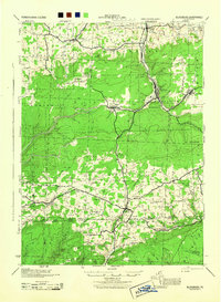
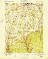 1948 Antrim1948 Print · USGSTioga County is captured here in the late 1940s, showing the critical rail connections between the borough of Wellsboro and the upland coal town of Antrim. Genealogists can locate family landmarks like the Shumway Cem, Mt Zion Ch, and the rural Heise Run Sch.
 - 1948 Map of Tiadaghton
 1948 Tiadaghton1948 Print · USGSThe Pennsylvania Grand Canyon region is captured here in the late 1940s, showing the vital rail links through Pine Creek Gorge. Trace family roots at West Branch Cem and explore old rail stops at Owasssee and Tiadaghton.2 unique versions available
 - 1950 Map of Morris
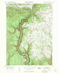
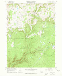
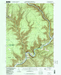
 1950 Morris1950 Print · USGSMid-century Tioga County comes alive in this survey of the high hollows and creek valleys surrounding Morris. Genealogists and historians can trace the Erie RR line, locate the Crawford Fire Tower, and explore old rural centers like Hoytville and Oregon Hill.
 - 1954 Map of Williamsport
 1954 Williamsport1954 Print · USGSNorth-central Pennsylvania in the mid-fifties is defined by the winding West Branch Susquehanna River and its industrial valley. Local historians can trace the massive Susquehanna Ordnance Depot and the extensive rail networks of the Pennsylvania Railroad.
 - 1960 Map of Williamsport
 1960 Williamsport1960 Print · USGSNorth-central Pennsylvania in the mid-twentieth century was a vital corridor of rail and river industry stretching from the New York line to the coal regions. Genealogists can trace the rail networks of the Pennsylvania RR and Lehigh Valley RR connecting towns like Williamsport, Towanda, and Lock Haven.
 - 1962 Map of Williamsport, 1966 Print
 1962 Williamsport1966 Print · USGSNorth-central Pennsylvania was a landscape of industrial river hubs and vast state woodlands in the early sixties. Researchers can trace the path of the Pennsylvania Railroad through Williamsport and explore the remote reaches of Bucktail State Park.5 unique versions available
 - 1965 Map of Williamsport
 1965 Williamsport1965 Print · USGSNorth-central Pennsylvania in the mid-1960s is defined by the industrial river towns and vast timberlands of the Allegheny Plateau. Researchers can trace historic rail lines like the Erie Lackawanna and Reading as they thread through Williamsport, Lock Haven, and Jersey Shore.
 - 1966 Map of Williamsport
 1966 Williamsport1966 Print · USGSThe Susquehanna Valley was a hub of transit and industry in the mid-seventies, where the river's West Branch connected major college towns and timberlands. Researchers can trace historical rail lines like the Reading or locate regional landmarks from Jersey Shore to Ricketts Glen State Park.
 - 1969 Map of Nauvoo, 1973 Print
 1969 Nauvoo1973 Print · USGSThe northern Pennsylvania high country is documented here in the late sixties, where small settlements like Nauvoo and Hartfield sit at the edge of the Tioga State Forest. Genealogists and researchers can trace local landmarks like Beuters Ch or the Old Babb Railroad Grade.3 unique versions available
 - 1970 Map of Cherry Flats, 1972 Print
 1970 Cherry Flats1972 Print · USGSTioga County’s highland communities and forest industry are preserved here as they appeared in the early seventies. Genealogists and historians can trace the Welsh Settlement area and its Welsh Settlement Ch, or follow the Old Railroad Grade through the Tioga State Forest.3 unique versions available
 - 1977 Map of Tiadaghton, 1979 Print
 1977 Tiadaghton1979 Print · USGSThe Pine Creek gorge and the agricultural uplands of Tioga County are captured in this late-1970s aerial survey. Researchers can trace rural property lines and the layouts of small settlements such as Dexter, Kennedy, and Olmsville.
 - 1977 Map of Nauvoo, 1979 Print
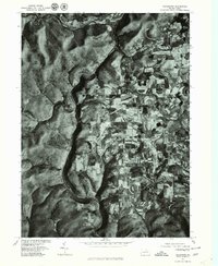
 1977 Nauvoo1979 Print · USGSDuring the late seventies, this rural Tioga County landscape was captured in fine detail via aerial photography. Researchers can pinpoint specific homesteads and land boundaries near Nauvoo, Hartfield, and Plank.
 - 1977 Map of Cedar Run, 1979 Print
 1977 Cedar Run1979 Print · USGSIn the Tioga County highlands during the late seventies, this aerial-view survey captures the isolated settlement at Cedar Run. Trace the deep valley floor where the village meets Pine Creek, revealing the forest cover and landscape as it truly was.
 - 1977 Map of Morris, 1979 Print
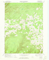
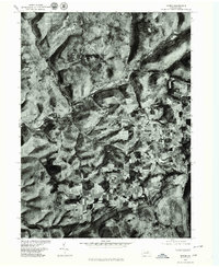 1977 Morris1979 Print · USGSTioga County agriculture and valley settlements are captured in high detail in the late seventies. Researchers can trace the layout of small communities like Morris and Mt Pleasant or examine the upland farms of Oregon Hill.
 - 1981 Map of Wellsboro, 1982 Print
 1981 Wellsboro1982 Print · USGSNorthern Pennsylvania in the early eighties shows a landscape of deep river gorges and vast state forests. Trace the rail lines of Conrail and explore old settlements from Coudersport to the Pine Creek Gorge.
 - 1994 Map of Cedar Run, 1998 Print
 1994 Cedar Run1998 Print · USGSThe deep canyons of the Grand Canyon of Pennsylvania are captured here during the late twentieth century. Researchers can trace the river-level settlements of Blackwell and Cedar Run or locate high-country landmarks like Mine Hole Hill and Leetonia.
Showing maps 1-25 of 33
Top cities near Morris Township
- Wellsboro historical maps
- Clymer Township historical maps
- Gaines Township historical maps
- Duncan Township historical maps
- Stony Fork historical maps
Top neighborhoods of Morris Township
- Lorenton historical maps
- Three Springs Run historical maps
- Pine historical maps
- Hoytville historical maps
- Doane historical maps
- Plank historical maps
See more
Frequently asked questions
- What are the different types of historical maps available for Morris Township?
- What is the oldest map of Morris Township?
- Where can I purchase historical maps of Morris Township for my home or office?
- Where can I download high-res historical maps of Morris Township?
- Are there historical topographic maps available for Morris Township?
- Is there historical aerial imagery available for Morris Township?
- Where are historical maps of Morris Township sourced from?