1960s Maps of Watson Township, Pennsylvania
Explore 3 historic maps of Watson Township from the 1960s. These maps offer a rare glimpse into what life looked like during the 1960s — showing old roads, neighborhoods, homes, and landmarks that have changed or disappeared over time.
Whether you're researching your family's past, planning a metal detecting trip, or studying how Watson Township's landscape evolved across the 1960s, these high-resolution maps are a powerful tool for exploring the history of this region.
- Focus on a specific era: All maps on this page are from the 1960s, giving you a focused view of this time period.
- See what’s changed: Compare century-old streets, trails, and buildings to today's modern landscape using overlays and satellite layers.
- Research with precision: Use these maps for genealogy, historical research, land use analysis, or educational projects.
- View, download, or print: Maps are fully viewable online in high resolution, and can be downloaded or printed for your own records.
Start exploring Watson Township's history through authentic maps from the 1960s. This is your window into the past.
Watson Township, PA maps
(3)- 1966 Map of Cobham, 1967 Print
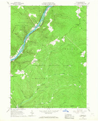 1966 Cobham1967 Print · USGSThe Allegheny River valley in Warren County was a mix of conservation land and resource extraction in the mid-sixties. Genealogists and historians can locate family-named landmarks like Bimber Corners, the Economite Cem, and the Plank Road Sch.3 unique versions available
 - 1966 Map of Cherry Grove, 1970 Print
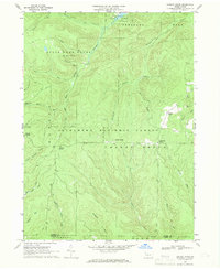 1966 Cherry Grove1970 Print · USGSThe Pennsylvania highlands in the mid-1960s reveal a landscape of forestry, oil extraction, and early recreation. Researchers can trace the Old Railroad Grade and Dunham Siding, or locate the Cherry Grove Cem and Oil Wells scattered across the plateau.4 unique versions available
 - 1969 Map of Youngsville, 1971 Print
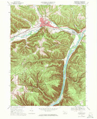 1969 Youngsville1971 Print · USGSYoungsville and the Allegheny River valley appear here in the late sixties, showing a landscape defined by industry and conservation. Local historians can trace the Penn Central rail lines and locate the County Home and Hospital or the historic St Lukes Ch.4 unique versions available
End of results
Showing maps 1-3 of 3
Top cities near Watson Township
- Warren historical maps
- Sheffield Township historical maps
- Glade historical maps
- North Warren historical maps
- Youngsville historical maps
- Pittsfield Township historical maps
See more
Top neighborhoods of Watson Township
Frequently asked questions
- What are the different types of historical maps available for Watson Township?
- What is the oldest map of Watson Township?
- Where can I purchase historical maps of Watson Township for my home or office?
- Where can I download high-res historical maps of Watson Township?
- Are there historical topographic maps available for Watson Township?
- Is there historical aerial imagery available for Watson Township?
- Where are historical maps of Watson Township sourced from?