1900-1909 Maps of West Finley Township, Pennsylvania
Explore 4 historic maps of West Finley Township from 1900-1909. These maps offer a rare glimpse into what life looked like during the 1900s — showing old roads, neighborhoods, homes, and landmarks that have changed or disappeared over time.
Whether you're researching your family's past, planning a metal detecting trip, or studying how West Finley Township's landscape evolved across the 1900s, these high-resolution maps are a powerful tool for exploring the history of this region.
- Focus on a specific era: All maps on this page are from the 1900s, giving you a focused view of this time period.
- See what’s changed: Compare century-old streets, trails, and buildings to today's modern landscape using overlays and satellite layers.
- Research with precision: Use these maps for genealogy, historical research, land use analysis, or educational projects.
- View, download, or print: Maps are fully viewable online in high resolution, and can be downloaded or printed for your own records.
Start exploring West Finley Township's history through authentic maps from the 1900s. This is your window into the past.
West Finley Township, PA maps
(4)- 1902 Map of Wheeling
 1902 Wheeling1902 Print · USGSThe Ohio River valley at the start of the 1900s was a powerhouse of rail and river industry across West Virginia, Ohio, and Pennsylvania. Genealogists can trace family roots in early industrial hubs like Martins Ferry, locate historic landmarks like the S Bridge, or find riverfront settlements such as Beach Bottom and Yorkville.7 unique versions available
 - 1904 Map of Cameron
 1904 Cameron1904 Print · USGSMarshall County's river-and-rail economy is frozen in time at the dawn of the century, showing the dense settlement patterns of the West Virginia panhandle. Researchers can trace the Baltimore and Ohio R R through Rosbys Rock or locate rural landmarks like Beelers Station and the Waynesburg Turnpike.4 unique versions available
 - 1905 Map of Rogersville
 1905 Rogersville1905 Print · USGSGreene and Washington counties are documented here at the turn of the century as a maze of ridge-and-valley settlements. Genealogists can trace early homesteads and commerce hubs like Harveys P.O. Graysville, Simpson Store, and Ryerson Station.4 unique versions available
 - 1907 Map of Claysville
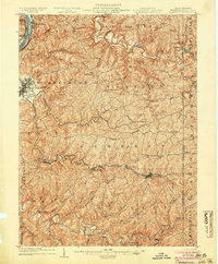
 1907 Claysville1907 Print · USGSWashington County during the first decade of the 1900s shows a dense network of hill-country townships connected by the Baltimore and Ohio RR. Researchers can trace rural life through numerous named schoolhouses and local post offices like Crothers PO and Vienna Coon Island PO.5 unique versions available
End of results
Showing maps 1-4 of 4
Top cities near West Finley Township
- Wheeling historical maps
- Washington historical maps
- South Strabane Township historical maps
- Bethlehem historical maps
- Buffalo historical maps
- Independence Township historical maps
See more
Top neighborhoods of West Finley Township
Frequently asked questions
- What are the different types of historical maps available for West Finley Township?
- What is the oldest map of West Finley Township?
- Where can I purchase historical maps of West Finley Township for my home or office?
- Where can I download high-res historical maps of West Finley Township?
- Are there historical topographic maps available for West Finley Township?
- Is there historical aerial imagery available for West Finley Township?
- Where are historical maps of West Finley Township sourced from?