1990s Maps of Preston Township, Pennsylvania
Explore 3 historic maps of Preston Township from the 1990s. These maps offer a rare glimpse into what life looked like during the 1990s — showing old roads, neighborhoods, homes, and landmarks that have changed or disappeared over time.
Whether you're researching your family's past, planning a metal detecting trip, or studying how Preston Township's landscape evolved across the 1990s, these high-resolution maps are a powerful tool for exploring the history of this region.
- Focus on a specific era: All maps on this page are from the 1990s, giving you a focused view of this time period.
- See what’s changed: Compare century-old streets, trails, and buildings to today's modern landscape using overlays and satellite layers.
- Research with precision: Use these maps for genealogy, historical research, land use analysis, or educational projects.
- View, download, or print: Maps are fully viewable online in high resolution, and can be downloaded or printed for your own records.
Start exploring Preston Township's history through authentic maps from the 1990s. This is your window into the past.
Preston Township, PA maps
(3)- 1992 Map of Lake Como, 1995 Print
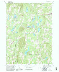
 1992 Lake Como1995 Print · USGSWayne County's lake country is captured here in the early 1990s, showing a landscape of seasonal camps and rural crossroads. Researchers can locate St Julianas Cem at Church Hill or trace the Old Railroad Grade near Dillontown.
 - 1992 Map of Orson, 1995 Print
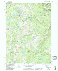
 1992 Orson1995 Print · USGSHigh in the lake country of Wayne County in the early nineties, this survey captures the headwaters of the Lackawanna. Genealogists can find family landmarks like Orson Cem, Hines Corners, and Orson Ch along the winding mountain roads.
 - 1992 Map of Hancock, 1995 Print
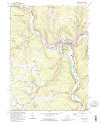 1992 Hancock1995 Print · USGSThe confluence of the Delaware River branches at the New York and Pennsylvania border highlights a landscape of river-town industry and highland lakes. Researchers can trace the rail lines through Hancock, locate family sites at Kingsbury Hill Cem, and explore the rural character of Starlight.2 unique versions available
End of results
Showing maps 1-3 of 3
Top cities near Preston Township
- Windsor historical maps
- Damascus Township historical maps
- Hancock historical maps
- Clifford Township historical maps
- Sanford historical maps
- Deposit historical maps
See more
Top neighborhoods of Preston Township
- Preston Park historical maps
- Shehawken historical maps
- East Spruce historical maps
- Lake Como historical maps
- Preston Corner historical maps
- Tallmanville historical maps
See more
Frequently asked questions
- What are the different types of historical maps available for Preston Township?
- What is the oldest map of Preston Township?
- Where can I purchase historical maps of Preston Township for my home or office?
- Where can I download high-res historical maps of Preston Township?
- Are there historical topographic maps available for Preston Township?
- Is there historical aerial imagery available for Preston Township?
- Where are historical maps of Preston Township sourced from?