1970s Maps of Ligonier Township, Pennsylvania
Explore 4 historic maps of Ligonier Township from the 1970s. These maps offer a rare glimpse into what life looked like during the 1970s — showing old roads, neighborhoods, homes, and landmarks that have changed or disappeared over time.
Whether you're researching your family's past, planning a metal detecting trip, or studying how Ligonier Township's landscape evolved across the 1970s, these high-resolution maps are a powerful tool for exploring the history of this region.
- Focus on a specific era: All maps on this page are from the 1970s, giving you a focused view of this time period.
- See what’s changed: Compare century-old streets, trails, and buildings to today's modern landscape using overlays and satellite layers.
- Research with precision: Use these maps for genealogy, historical research, land use analysis, or educational projects.
- View, download, or print: Maps are fully viewable online in high resolution, and can be downloaded or printed for your own records.
Start exploring Ligonier Township's history through authentic maps from the 1970s. This is your window into the past.
Ligonier Township, PA maps
(4)- 1973 Map of Rachelwood, 1984 Print
 1973 Rachelwood1984 Print · USGSLaurel Hill and its surrounding valleys are captured here in the early seventies, showing a landscape defined by mountain ridges and river forks. Trace local history through the Baldwin Furnace, Legat Cem, and the rural Church in the Wilderness.
 - 1977 Map of Boswell, 1979 Print
 1977 Boswell1979 Print · USGSSomerset County's rural and town landscapes are captured in the late seventies through high-resolution aerial imagery. Trace the street grids and field patterns around Boswell and Jennerstown or follow the banks of Quemahoning Creek.
 - 1977 Map of Ligonier, 1979 Print
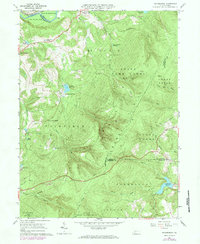
 1977 Ligonier1979 Print · USGSWestmoreland County hill country is captured in the late seventies, showing the established communities and mountain developments of the Ligonier Valley. Researchers can trace the boundaries of Laughlintown, the layout of Rector, and the waters of Loyalhanna Creek.
 - 1977 Map of Rachelwood, 1979 Print
 1977 Rachelwood1979 Print · USGSWestmoreland County rural life and water infrastructure are captured in this late-seventies aerial survey. Local researchers can trace the footprint of Rachelwood and locate major landmarks like Tubmill Reservoir and Mirror Lake.
End of results
Showing maps 1-4 of 4
Top cities near Ligonier Township
- Latrobe historical maps
- Somerset historical maps
- Blairsville historical maps
- Derry historical maps
- Loyalhanna historical maps
- Black Lick Township historical maps
See more
Top neighborhoods of Ligonier Township
- Shirley historical maps
- Thomas Crossroads historical maps
- Rector historical maps
- Waterford historical maps
- Bells historical maps
- Buttermilk Falls historical maps
See more
Frequently asked questions
- What are the different types of historical maps available for Ligonier Township?
- What is the oldest map of Ligonier Township?
- Where can I purchase historical maps of Ligonier Township for my home or office?
- Where can I download high-res historical maps of Ligonier Township?
- Are there historical topographic maps available for Ligonier Township?
- Is there historical aerial imagery available for Ligonier Township?
- Where are historical maps of Ligonier Township sourced from?