1940s Maps of Kaiserville, Washington Township
Explore 3 historic maps of Kaiserville from the 1940s. These maps offer a rare glimpse into what life looked like during the 1940s — showing old roads, neighborhoods, homes, and landmarks that have changed or disappeared over time.
Whether you're researching your family's past, planning a metal detecting trip, or studying how Kaiserville's landscape evolved across the 1940s, these high-resolution maps are a powerful tool for exploring the history of this region.
- Focus on a specific era: All maps on this page are from the 1940s, giving you a focused view of this time period.
- See what’s changed: Compare century-old streets, trails, and buildings to today's modern landscape using overlays and satellite layers.
- Research with precision: Use these maps for genealogy, historical research, land use analysis, or educational projects.
- View, download, or print: Maps are fully viewable online in high resolution, and can be downloaded or printed for your own records.
Start exploring Kaiserville's history through authentic maps from the 1940s. This is your window into the past.
Kaiserville, Washington Township maps
(3)- 1946 Map of Tunkhannock, 1952 Print
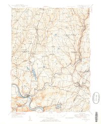 1946 Tunkhannock1952 Print · USGSThe northern Susquehanna River valley and the Wyoming County highlands are captured here in the mid-1940s. Genealogists and historians can trace the rail-connected settlements of Nicholson and Springville or locate family landmarks like Bunnell Cem and Castle Sch.3 unique versions available
 - 1946 Map of Tunkhannock, 1971 Print
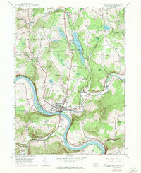 1946 Tunkhannock1971 Print · USGSTunkhannock and the winding Susquehanna River are captured here in the mid-twentieth century as the regional rail and road networks matured. Researchers can locate family sites at Sunnyside Cem, old rural schoolhouses like Castle Sch, and the grounds of St Andrews Camp.3 unique versions available
 - 1948 Map of Tunkhannock
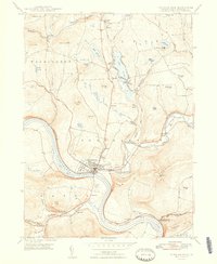 1948 Tunkhannock1948 Print · USGSTunkhannock and the Susquehanna River valley are captured here in the years following World War II, showing a landscape defined by rail and river. Genealogists can trace family names and local landmarks like Osterhout PO, Castle Sch, and Sunnyside Cem.2 unique versions available
End of results
Showing maps 1-3 of 3
Top cities near Kaiserville
- Dallas Township historical maps
- Bridgewater Township historical maps
- Falls Township historical maps
- Lenox Township historical maps
- Tunkhannock historical maps
- Springville Township historical maps
See more
Frequently asked questions
- What are the different types of historical maps available for Kaiserville?
- What is the oldest map of Kaiserville?
- Where can I purchase historical maps of Kaiserville for my home or office?
- Where can I download high-res historical maps of Kaiserville?
- Are there historical topographic maps available for Kaiserville?
- Is there historical aerial imagery available for Kaiserville?
- Where are historical maps of Kaiserville sourced from?