1940s Maps of Glocester, Rhode Island
Explore 9 historic maps of Glocester from the 1940s. These maps offer a rare glimpse into what life looked like during the 1940s — showing old roads, neighborhoods, homes, and landmarks that have changed or disappeared over time.
Whether you're researching your family's past, planning a metal detecting trip, or studying how Glocester's landscape evolved across the 1940s, these high-resolution maps are a powerful tool for exploring the history of this region.
- Focus on a specific era: All maps on this page are from the 1940s, giving you a focused view of this time period.
- See what’s changed: Compare century-old streets, trails, and buildings to today's modern landscape using overlays and satellite layers.
- Research with precision: Use these maps for genealogy, historical research, land use analysis, or educational projects.
- View, download, or print: Maps are fully viewable online in high resolution, and can be downloaded or printed for your own records.
Start exploring Glocester's history through authentic maps from the 1940s. This is your window into the past.
Glocester, RI maps
(9)- 1943 Map of Clayville
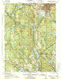
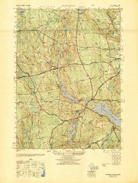
 1943 Clayville1943 Print · USGSThe rural uplands of Providence County are shown during the mid-forties, characterized by a complex network of reservoirs and historic crossroads. Researchers can trace ancestral sites at the Stone Plot, New Rockland Cem, and the old Ponaganset Sch near South Foster.4 unique versions available
 - 1943 Map of North Scituate
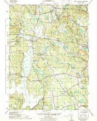 1943 North Scituate1943 Print · USGSProvidence County during the early 1940s reveals a region defined by the massive Scituate Reservoir and its supporting infrastructure. Researchers can locate family landmarks like the Scituate Town House, Smithville Cem, and several neighborhood schools including the Brown Ave Sch.4 unique versions available
 - 1943 Map of Chepachet
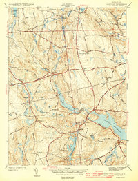
 1943 Chepachet1943 Print · USGSProvidence County's upland villages and reservoirs are shown here during the early 1940s. Genealogists can trace family landmarks like Tourtellotte Hill and Chepachet Cem, or locate the Pascoag Race Track and local schools.3 unique versions available
 - 1943 Map of Georgiaville
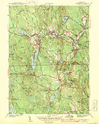
 1943 Georgiaville1943 Print · USGSProvidence County is seen here during the early 1940s, highlighting the industrial mill towns along the Branch and Woonasquatucket Rivers. Genealogists and researchers can trace family-named landmarks like Steere Hill or find local community centers such as Union Chapel and The Shrine near Nasonville.3 unique versions available
 - 1943 Map of Putnam, 1944 Print
 1943 Putnam1944 Print · USGSThe Connecticut and Rhode Island borderlands are captured here during the wartime era, showing a landscape defined by textile river towns and sprawling state forests. Trace the industrial rail corridor of the New York New Haven and Hartford through Putnam, Danielson, and Moosup.
 - 1945 Map of East Killingly
 1945 East Killingly1945 Print · USGSThe Connecticut and Rhode Island borderlands are captured here in the mid-1940s, showing a landscape of textile-era reservoirs and upland farms. Researchers can trace historic family burial grounds like Fiske Cem and Paine Cem or locate long-standing rural schoolhouses such as the Mt Hygeia Sch.2 unique versions available
 - 1947 Map of Providence, 1948 Print
 1947 Providence1948 Print · USGSSouthern New England is captured in the mid-1940s, showing a landscape defined by busy industrial ports and expanding military installations. Researchers can trace the rail lines of the N.Y. N.H. & H. RR or locate coastal defenses like Fort Adams and Quonset Point.5 unique versions available
 - 1948 Map of Clayville, 1949 Print
 1948 Clayville1949 Print · USGSProvidence County’s western uplands appear here in the late forties, showing a landscape shaped by significant reservoirs and historical turnpikes. Researchers can locate numerous family burial sites like Wilder Cem and Spear Cem or trace the old roads through South Foster and Foster Center.
 - 1948 Map of Providence, 1951 Print
 1948 Providence1951 Print · USGSSouthern New England’s coastal reaches are captured here in the late 1940s, from the industrial heart of Providence to the tip of Provincetown. Genealogists and historians can trace rail lines like the Central Vermont Railway and locate active military sites such as Otis Air Force Base and Fort Rodman.
End of results
Showing maps 1-9 of 9
Top cities near Glocester
- Providence historical maps
- Warwick historical maps
- Cranston historical maps
- Woonsocket historical maps
- Coventry historical maps
- Cumberland historical maps
See more
Top neighborhoods of Glocester
- Harmony historical maps
- Chepachet historical maps
- Clarkville historical maps
- West Glocester historical maps
- Waldron Corners historical maps
- Wescott Beach historical maps
See more
Frequently asked questions
- What are the different types of historical maps available for Glocester?
- What is the oldest map of Glocester?
- Where can I purchase historical maps of Glocester for my home or office?
- Where can I download high-res historical maps of Glocester?
- Are there historical topographic maps available for Glocester?
- Is there historical aerial imagery available for Glocester?
- Where are historical maps of Glocester sourced from?