1980s Maps of Little Water, Shiprock Agency
Explore 2 historic maps of Little Water from the 1980s. These maps offer a rare glimpse into what life looked like during the 1980s — showing old roads, neighborhoods, homes, and landmarks that have changed or disappeared over time.
Whether you're researching your family's past, planning a metal detecting trip, or studying how Little Water's landscape evolved across the 1980s, these high-resolution maps are a powerful tool for exploring the history of this region.
- Focus on a specific era: All maps on this page are from the 1980s, giving you a focused view of this time period.
- See what’s changed: Compare century-old streets, trails, and buildings to today's modern landscape using overlays and satellite layers.
- Research with precision: Use these maps for genealogy, historical research, land use analysis, or educational projects.
- View, download, or print: Maps are fully viewable online in high resolution, and can be downloaded or printed for your own records.
Start exploring Little Water's history through authentic maps from the 1980s. This is your window into the past.
Little Water, Shiprock Agency maps
(2)- 1983 Map of Bluff
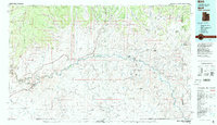 1983 Bluff1983 Print · USGSThe San Juan River country in the early 1980s reveals a landscape of high mesas and indigenous settlements. Trace the rugged terrain of Comb Ridge, locate the Hatch Trading Post, and explore the roads connecting Bluff to Mexican Hat.2 unique versions available
 - 1989 Map of Boundary Butte
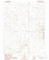 1989 Boundary Butte1989 Print · USGSThe Navajo Nation's high desert plateaus in San Juan County are captured here in the late eighties, just as energy exploration marked the terrain. Researchers can locate remote landmarks like Boundary Butte, Sand Spring, and several Oil Wells across the Nokaito Bench.
End of results
Showing maps 1-2 of 2
Top cities near Little Water
Frequently asked questions
- What are the different types of historical maps available for Little Water?
- What is the oldest map of Little Water?
- Where can I purchase historical maps of Little Water for my home or office?
- Where can I download high-res historical maps of Little Water?
- Are there historical topographic maps available for Little Water?
- Is there historical aerial imagery available for Little Water?
- Where are historical maps of Little Water sourced from?