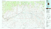
1983 Map of Bluff
USGS Topo · Published 1983About this map
The San Juan River carves a deep path across this 1983 landscape, serving as the central artery for a region defined by dramatic sandstone formations and high desert mesas. This era shows the established community of Bluff and the village of Mexican Hat anchoring the western corridor, while the eastern portion highlights the Aneth area and the Ismay Oil Field Road, reflecting the importance of energy extraction in the local economy. The map provides a detailed view of the Navajo Indian Reservation and Ute Mountain Indian Reservation boundaries, which encompass numerous traditional settlements like Red Lake Village and White Mesa Village. Landforms such as the massive Comb Ridge and Casa Del Eco Mesa create a natural labyrinth, with cultural landmarks like Hatch Trading Post and Hovenweep National Monument marking the intersection of historic trade and ancestral sites.
Find a feature on this map
67 named features on this map. Tap any name to fly to it.
Don’t see what you’re looking for? This feature index may not catch every label — zoom into the map to look around manually.
Map Details
Editions of this 1983 Bluff Map
2 editions found
Other maps of this area

1883 · Marsh Pass
USGS Topo · 1:250,000

1886 · Henry Mountains
USGS Topo · 1:250,000

1886 · Abajo
USGS Topo · 1:250,000

1889 · Chaco
USGS Topo · 1:250,000

1892 · Marsh Pass
USGS Topo · 1:250,000

1892 · Abajo
USGS Topo · 1:250,000

1892 · Henry Mountains
USGS Topo · 1:250,000

1892 · Chaco
USGS Topo · 1:250,000

1892 · Canyon De Chelly
USGS Topo · 1:250,000

1893 · Abajo
USGS Topo · 1:250,000
Featured Places
- Shiprock Agency
- Bluff, UT
- Mexican Hat, UT
- White Rock Curve Village, Shiprock Agency
- Red Lake Village, Shiprock Agency