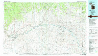
1983 Map of Bluff
USGS Topo · Published 1983About this map
The San Juan River carves a winding path through this high desert region of southeastern Utah, serving as the primary geographic axis for settlements like Bluff and Mexican Hat. This 1983 edition captures the region's complex cultural and industrial landscape, dominated by the Navajo Indian Reservation and the distinctive geological features of Monument Valley and the Valley of the Gods. The map documents a period of significant resource extraction, prominently featuring the Aneth Oil Field and the Ismay Oil Field near the Colorado border.
Find a feature on this map
69 named features on this map. Tap any name to fly to it.
Don’t see what you’re looking for? This feature index may not catch every label — zoom into the map to look around manually.
Map Details
Editions of this 1983 Bluff Map
2 editions found
Other maps of this area

1883 · Marsh Pass
USGS Topo · 1:250,000

1886 · Henry Mountains
USGS Topo · 1:250,000

1886 · Abajo
USGS Topo · 1:250,000

1889 · Chaco
USGS Topo · 1:250,000

1892 · Marsh Pass
USGS Topo · 1:250,000

1892 · Abajo
USGS Topo · 1:250,000

1892 · Henry Mountains
USGS Topo · 1:250,000

1892 · Chaco
USGS Topo · 1:250,000

1892 · Canyon De Chelly
USGS Topo · 1:250,000

1893 · Abajo
USGS Topo · 1:250,000
Featured Places
- Shiprock Agency
- Bluff, UT
- Mexican Hat, UT
- White Rock Curve Village, Shiprock Agency
- Red Lake Village, Shiprock Agency