Old Maps of Kiawah Island, South Carolina for Hiking & Exploration
Hike through history with 49 historic maps of Kiawah Island. Explore old trails, ghost towns, and forgotten backroads — perfect for outdoor adventurers and local explorers.
- Rediscover forgotten places: Map out old mining camps, roads, and footpaths that no longer exist on modern maps.
- Layer with modern tools: Combine with LiDAR or satellite views to plan hikes through historical terrain.
- Made for exploration: Popular among hikers, overlanders, and local history lovers.
Use these maps to find adventure and explore the hidden past of Kiawah Island.
Kiawah Island, SC maps
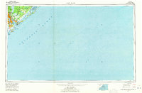
(49)- 1918 Map of Kiawah Island
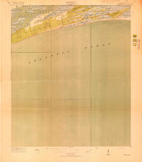 1918 Kiawah Island1918 Print · USGSCoastal South Carolina remains a wilderness of woods and brush during the Great War era. Researchers can trace the early layout of Kiawah Island, identifying landmarks like Avenue Road, Eagle Point, and the eastern tip at Sandy Point.2 unique versions available
 - 1919 Map of Wadmelaw Island
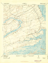
 1919 Wadmelaw Island1919 Print · USGSCoastal South Carolina is mapped here just after the Great War, showing a landscape of sea island plantations and tidal waterways. Researchers can locate remote settlements like Rockville and Legareville, as well as rural landmarks like Crate Mill and St Johns Church.2 unique versions available
 - 1919 Map of James Island
 1919 James Island1919 Print · USGSThe marshlands and small coastal communities of James Island are documented here at the end of the Great War. Genealogists and historians can trace old homesteads and roads through Centerville, find the Payne Chapel, and locate maritime landmarks like the Charleston LH.2 unique versions available
 - 1919 Map of Legareville
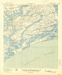
 1919 Legareville1919 Print · USGSCoastal Charleston County comes to life in the years following the Great War, showing the intricate salt marshes and islands before modern development. Genealogists can locate family homes and community centers like Legareville, Sandhill School, and Mt Zion Church.2 unique versions available
 - 1943 Map of Legareville
 1943 Legareville1943 Print · USGSThe South Carolina lowcountry islands are captured here during the 1940s, showing a world of tidal creeks and rural island life. Genealogists can trace family footprints at Legareville, Miller Hill, and local landmarks like Sandhill School and Zion Church.2 unique versions available
 - 1943 Map of James Island
 1943 James Island1943 Print · USGSCoastal South Carolina comes alive in the mid-1940s, revealing a landscape of tidal marshes and early island settlements. Trace family roots and maritime history through Secessionville, Payne Chapel, and the Morris Island Coast Guard Station.2 unique versions available
 - 1943 Map of Kiawah Island
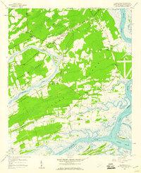
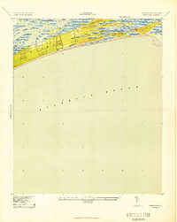 1943 Kiawah Island1943 Print · USGSKiawah Island and the South Carolina coast appear here during the mid-forties, showing the landscape as a quiet expanse of tidal marshes and beaches. Researchers can trace the winding course of the Kiawah River and identify landmarks like Cinder Point and Sandy Point.2 unique versions available
 - 1944 Map of Wadmelaw Island
 1944 Wadmelaw Island1944 Print · USGSThe South Carolina Lowcountry islands are captured here in the early twentieth century, showing a landscape of tidal creeks and remote coastal settlements. Genealogists can locate family landmarks such as Rockville, Legareville, and several country schools like Bogle School.2 unique versions available
 - 1947 Map of Savannah
 1947 Savannah1947 Print · USGSCoastal Georgia and South Carolina are captured here in the mid-forties, showing the rail-and-river networks of the Lowcountry. Genealogists and researchers can trace old crossroads and river towns from Statesboro to Beaufort, alongside military sites like Camp Stewart and Parris Island.
 - 1948 Map of James Island
 1948 James Island1948 Print · USGSThe South Carolina coast around the harbor city appeared in this postwar period as a network of naval defenses and established sea island communities. Trace the roads and waterways connecting Charleston to Fort Sumter, Mt Pleasant, and the Isle of Palms.2 unique versions available
 - 1948 Map of Savannah
 1948 Savannah1948 Print · USGSThe Georgia and South Carolina Lowcountry comes alive in this post-war survey of the coast and its river-fed hinterlands. Genealogists and historians can trace rail lines like the Central of Georgia RR and find established settlements such as Isle of Hope and Sylvania.
 - 1957 Map of Savannah, 1967 Print
 1957 Savannah1967 Print · USGSThe Lowcountry and Georgia coastal plain are shown here in the late fifties, prior to modern expansion. Researchers can trace the rail-and-river economy through the Central of Georgia lines and the Ogeechee River wetlands.4 unique versions available
 - 1959 Map of Legareville, 1960 Print
 1959 Legareville1960 Print · USGSJohns Island and the surrounding South Carolina Lowcountry are captured in the late fifties, showing a rural landscape of tidal creeks and church-centered communities. Genealogists and historians can trace family locations near Legareville, Fenwick Crossroads, and several schools including Haut Gap Sch.3 unique versions available
 - 1959 Map of James Island, 1960 Print
 1959 James Island1960 Print · USGSThe coastal marshlands and barrier islands of the Charleston area are captured here during a period of mid-century growth. Genealogists and historians can trace family-named sites and landmarks like Secessionville, Sol Legare Island, and the Loran Coast Guard Station.4 unique versions available
 - 1959 Map of Kiawah Island, 1960 Print
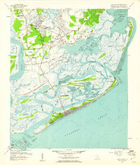
 1959 Kiawah Island1960 Print · USGSCoastal South Carolina remains largely untouched in the late fifties, prior to the island's modern development. Trace the original footprints of Kiawah Island Drive and the natural winding paths of Cinder Creek and the Kiawah River.3 unique versions available
 - 1960 Map of Savannah
 1960 Savannah1960 Print · USGSCoastal Georgia and the South Carolina Lowcountry are captured in the late fifties, showcasing the intricate web of islands and tidal rivers before modern expansion. Researchers can trace the rail lines of the Atlantic Coast Line or locate sites like Parris Island, Beaufort, and the Tybee Lighthouse.
 - 1960 Map of Rockville, 1964 Print
 1960 Rockville1964 Print · USGSThe South Carolina Lowcountry remains a world of winding tidal creeks and quiet island settlements during the early 1960s. Genealogists and local historians can trace the foundations of Rockville and Rockland or locate St Johns Ch and the coastal landmarks of Seabrook Island.4 unique versions available
 - 1961 Map of Savannah
 1961 Savannah1961 Print · USGSThe Georgia and South Carolina Lowcountry comes alive in this mid-century survey of coastal marshes, barrier islands, and river networks. Genealogists and historians can trace the paths of the Seaboard Air Line RR, locate family sites near Isle of Hope, or study the grounds of Fort Stewart Military Reservation.2 unique versions available
 - 1968 Map of James Island
 1968 James Island1968 Print · USGSThe South Carolina Lowcountry in the late sixties shows a transition between its historic coastal defenses and modern expansion. Trace the harbor landscape from Charleston to the barrier islands, finding landmarks like Fort Sumter, Fort Moultrie, and Carolina Skyways.
 - 1969 Map of James Island, 1971 Print
 1969 James Island1971 Print · USGSThe South Carolina coast and Charleston Harbor are documented here in the late sixties, showing a landscape defined by naval history and barrier island growth. Genealogists and historians can trace the footprint of Scanlonville, Folly Beach, and the historic Ft Moultrie.2 unique versions available
 - 1986 Map of James Island
 1986 James Island1986 Print · USGSCharleston and its surrounding sea islands are captured in the mid-1980s, showcasing a region defined by maritime heritage and rapid coastal expansion. Genealogists and historians can trace established neighborhoods like Scanlonville, landmarks such as Fort Sumter, and the era's infrastructure including the Grace Mem Br.
 - 1986 Map of Walterboro
 1986 Walterboro1986 Print · USGSThe South Carolina Lowcountry in the mid-eighties remains a world of expansive wetlands and historic river crossings. Genealogists and historians can trace the rural communities and landmarks of Colleton and Charleston counties, from the Baptist Church at Adams Run to the coastal reaches of Edisto Beach State Park.
 - 1990 Map of Walterboro
 1990 Walterboro1990 Print · USGSCoastal South Carolina and its dense river networks are documented here in the early nineties as the Charleston suburbs expanded westward. Genealogists and historians can trace old community hubs like Clubhouse Crossroads, the site of Givhans Ferry, and several Strip Mines north of the Stono River.
 - 1990 Map of James Island
 1990 James Island1990 Print · USGSCoastal South Carolina in the early nineties reveals a landscape where historic harbor defenses and naval installations meet expanding suburban reaches. Trace the evolution of waterfront communities from Folly Beach to Mount Pleasant, and locate maritime landmarks like the USS Yorktown State Park or the Lighthouse on Morris Island.
 - 2011 Map of James Island, 2011 Print
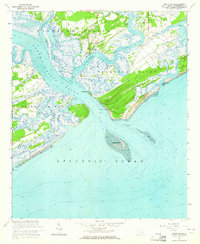
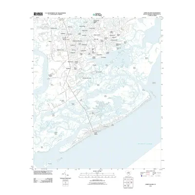 2011 James Island2011 Print · USGSCovers Kiawah Island, including Charleston, Folly Beach, and other nearby areas
Showing maps 1-25 of 49
Top cities near Kiawah Island
- Charleston historical maps
- North Charleston historical maps
- Mount Pleasant historical maps
- Hollywood historical maps
- Ravenel historical maps
- Folly Beach historical maps
See more
Top neighborhoods of Kiawah Island
- Vanderhorst historical maps
- West Beach historical maps
- East Beach historical maps
- Ocean Park historical maps
- Oyster Rake historical maps
- The Pointe historical maps
See more
Frequently asked questions
- What are the different types of historical maps available for Kiawah Island?
- What is the oldest map of Kiawah Island?
- Where can I purchase historical maps of Kiawah Island for my home or office?
- Where can I download high-res historical maps of Kiawah Island?
- Are there historical topographic maps available for Kiawah Island?
- Is there historical aerial imagery available for Kiawah Island?
- Where are historical maps of Kiawah Island sourced from?