1970s Maps of Davis Crossroads, South Carolina
Explore 2 historic maps of Davis Crossroads from the 1970s. These maps offer a rare glimpse into what life looked like during the 1970s — showing old roads, neighborhoods, homes, and landmarks that have changed or disappeared over time.
Whether you're researching your family's past, planning a metal detecting trip, or studying how Davis Crossroads's landscape evolved across the 1970s, these high-resolution maps are a powerful tool for exploring the history of this region.
- Focus on a specific era: All maps on this page are from the 1970s, giving you a focused view of this time period.
- See what’s changed: Compare century-old streets, trails, and buildings to today's modern landscape using overlays and satellite layers.
- Research with precision: Use these maps for genealogy, historical research, land use analysis, or educational projects.
- View, download, or print: Maps are fully viewable online in high resolution, and can be downloaded or printed for your own records.
Start exploring Davis Crossroads's history through authentic maps from the 1970s. This is your window into the past.
Davis Crossroads, SC maps
(2)- 1971 Map of Summerton
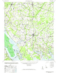 1971 Summerton1971 Print · USGSThe Clarendon County countryside comes alive in this mid-century survey, showing the transition from the Poinsett forest to the shores of Lake Marion. Genealogists can trace family roots through numerous local landmarks like Wells Sch, St Pauls Ch, and the historic Fort Watson.2 unique versions available
 - 1979 Map of Summerton, 1980 Print
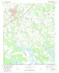 1979 Summerton1980 Print · USGSSummerton and the rural reaches of Clarendon County are captured here in the late seventies as the community sits adjacent to the Santee National Wildlife Refuge. Researchers can find many family-named sites and country churches, including Briggs Chapel, Davis Station, and Springhill Sch.
End of results
Showing maps 1-2 of 2
Top cities near Davis Crossroads
- Manning historical maps
- Summerton historical maps
- Santee historical maps
- Pinewood historical maps
- Eutawville historical maps
- Paxville historical maps
See more
Frequently asked questions
- What are the different types of historical maps available for Davis Crossroads?
- What is the oldest map of Davis Crossroads?
- Where can I purchase historical maps of Davis Crossroads for my home or office?
- Where can I download high-res historical maps of Davis Crossroads?
- Are there historical topographic maps available for Davis Crossroads?
- Is there historical aerial imagery available for Davis Crossroads?
- Where are historical maps of Davis Crossroads sourced from?