1970s Maps of Dillon County, South Carolina
Explore 12 historic maps of Dillon County from the 1970s. These maps offer a rare glimpse into what life looked like during the 1970s — showing old roads, neighborhoods, homes, and landmarks that have changed or disappeared over time.
Whether you're researching your family's past, planning a metal detecting trip, or studying how Dillon County's landscape evolved across the 1970s, these high-resolution maps are a powerful tool for exploring the history of this region.
- Focus on a specific era: All maps on this page are from the 1970s, giving you a focused view of this time period.
- See what’s changed: Compare century-old streets, trails, and buildings to today's modern landscape using overlays and satellite layers.
- Research with precision: Use these maps for genealogy, historical research, land use analysis, or educational projects.
- View, download, or print: Maps are fully viewable online in high resolution, and can be downloaded or printed for your own records.
Start exploring Dillon County's history through authentic maps from the 1970s. This is your window into the past.
Dillon County, SC maps
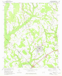
(12)- 1971 Map of Minturn, 1975 Print
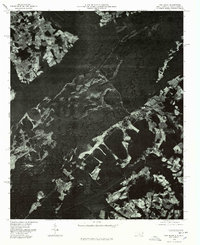
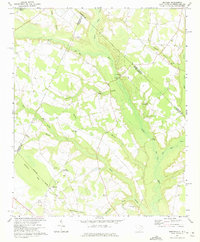 1971 Minturn1975 Print · USGSThe Carolina borderlands near the start of the 1970s show a landscape shaped by river crossings and rural parish life. Genealogists and historians can trace family locations through landmarks like Minturn, Sinclair Crossroads, and the Seaboard Coast Line railroad.
 - 1972 Map of Clio, 1975 Print
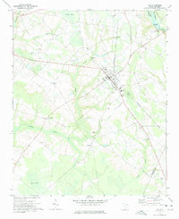 1972 Clio1975 Print · USGSCoastal plain agriculture and rail-side commerce define this South Carolina landscape during the early seventies. Genealogists can trace family footprints through numerous rural landmarks like Old Clio Ch, Lucas Cem, and the crossroads at Five Forks.
 - 1972 Map of Oak Grove, 1975 Print
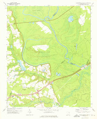
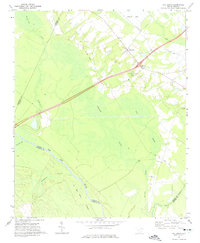 1972 Oak Grove1975 Print · USGSDillon County at the start of the 1970s is a landscape of expansive wetlands and river-bottom timber defined by the winding Pee Dee River. Researchers can trace old transportation corridors along the Old RR Grade and locate rural landmarks like Bethesda Ch or Haselden Cem.2 unique versions available
 - 1972 Map of Bingham, 1975 Print
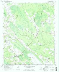 1972 Bingham1975 Print · USGSThe wetlands and rural settlements of the Marlboro and Dillon county border are detailed here during the early seventies. Genealogists and local historians can trace the Old Railroad Grade and locate family landmarks like Victory Temple and Bingham.2 unique versions available
 - 1972 Map of Rowland, 1976 Print
 1972 Rowland1976 Print · USGSThe North Carolina and South Carolina borderlands were a patchwork of tobacco fields and swampy timberlands in the early seventies. Genealogists can trace family footprints through numerous rural landmarks like Alfordsville, Salem Ch, and the Baker Cem.2 unique versions available
 - 1972 Map of Witherspoon Island, 1976 Print
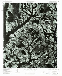
 1972 Witherspoon Island1976 Print · USGSThe Pee Dee River lowlands come to life in the early 1970s, showcasing the intricate water systems surrounding Witherspoon Island. Researchers can trace local family landmarks near Blacks, including Century Ch and Cem, or locate industrial sites like the Fish Hatchery.2 unique versions available
 - 1976 Map of Dillon East
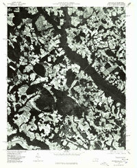
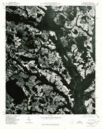
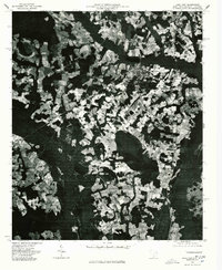
 1976 Dillon East1976 Print · USGSDillon and the surrounding Carolina borderlands are captured from the air during the mid-seventies, showing the region's agricultural and industrial patterns. Local historians can trace the development of Dillon or locate smaller settlements like Hamer and Stewarts Crossroads.2 unique versions available
 - 1976 Map of Gaddysville, 1978 Print
 1976 Gaddysville1978 Print · USGSRobeson County near the South Carolina line is seen here in the mid-seventies through detailed aerial orthophotography. Researchers can trace rural settlement patterns and field boundaries around Gaddysville, Five Forks, and White Pond.
 - 1976 Map of Minturn, 1978 Print
 1976 Minturn1978 Print · USGSThe Carolina borderlands come into focus in the mid-seventies through this detailed aerial orthophoto. Local historians and genealogists can trace property lines and land use patterns around Minturn, Crossroads, and the Little Pee Dee River.
 - 1976 Map of Fair Bluff, 1978 Print
 1976 Fair Bluff1978 Print · USGSThe Lumber River basin comes into sharp focus during the mid-seventies, showing the intersection of North and South Carolina. Researchers can trace the river's path past Fair Bluff or locate smaller outposts like Marietta and Causey.
 - 1976 Map of Lake View, 1978 Print
 1976 Lake View1978 Print · USGSThe rural landscapes of Dillon County come to life in the mid-1970s, showcasing the agricultural heart of the South Carolina borderlands. Researchers can trace the layout of Lake View and locate outlying communities like Hodgesville and May Hilltop.
 - 1976 Map of Rowland, 1978 Print
 1976 Rowland1978 Print · USGSThe town of Rowland and the surrounding Robeson County farmland are seen from the air in the mid-1970s. Trace the rural landscape through Alfordsville, Purvis, and the junction at Oakland Crossroads.
End of results
Showing maps 1-12 of 12
Top cities of Dillon County
Frequently asked questions
- What are the different types of historical maps available for Dillon County?
- What is the oldest map of Dillon County?
- Where can I purchase historical maps of Dillon County for my home or office?
- Where can I download high-res historical maps of Dillon County?
- Are there historical topographic maps available for Dillon County?
- Is there historical aerial imagery available for Dillon County?
- Where are historical maps of Dillon County sourced from?