1940s Maps of Pawleys Island, South Carolina
Explore 3 historic maps of Pawleys Island from the 1940s. These maps offer a rare glimpse into what life looked like during the 1940s — showing old roads, neighborhoods, homes, and landmarks that have changed or disappeared over time.
Whether you're researching your family's past, planning a metal detecting trip, or studying how Pawleys Island's landscape evolved across the 1940s, these high-resolution maps are a powerful tool for exploring the history of this region.
- Focus on a specific era: All maps on this page are from the 1940s, giving you a focused view of this time period.
- See what’s changed: Compare century-old streets, trails, and buildings to today's modern landscape using overlays and satellite layers.
- Research with precision: Use these maps for genealogy, historical research, land use analysis, or educational projects.
- View, download, or print: Maps are fully viewable online in high resolution, and can be downloaded or printed for your own records.
Start exploring Pawleys Island's history through authentic maps from the 1940s. This is your window into the past.
Pawleys Island, SC maps
(3)- 1942 Map of Magnolia Beach, 1962 Print
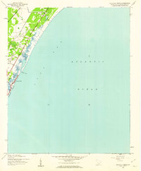 1942 Magnolia Beach1962 Print · USGSThe Georgetown County coast in the early 1940s shows a landscape of tidal creeks and rising beach communities. Genealogists and local researchers can trace the early footprints of Georgieville, Annieville, and the historic barrier of Pawleys Island.2 unique versions available
 - 1942 Map of Waverly Mills, 1962 Print
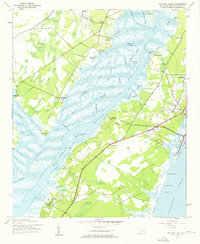 1942 Waverly Mills1962 Print · USGSThe Waccamaw and Pee Dee rivers meet in this wartime survey, showing a landscape of riverfront estates and early coastal settlements. Genealogists and historians can trace the grounds of Arundel Plantation, locate All Saints Ch, and see Marysville before the era of modern development.3 unique versions available
 - 1949 Map of Georgetown, 1953 Print
 1949 Georgetown1953 Print · USGSThe South Carolina coast and North Carolina borderlands appear here in the mid-century, prior to the major modern development of the Grand Strand. Genealogists and historians can trace the rail networks of the Seaboard Air Line Railroad and locate coastal landmarks from Fort Caswell to McClellanville.
End of results
Showing maps 1-3 of 3
Top cities near Pawleys Island
- Garden City Beach historical maps
- Georgetown historical maps
- Murrells Inlet historical maps
- Litchfield Beach historical maps
- Surfside Beach historical maps
- DeBordieu Colony historical maps
Top neighborhoods of Pawleys Island
Frequently asked questions
- What are the different types of historical maps available for Pawleys Island?
- What is the oldest map of Pawleys Island?
- Where can I purchase historical maps of Pawleys Island for my home or office?
- Where can I download high-res historical maps of Pawleys Island?
- Are there historical topographic maps available for Pawleys Island?
- Is there historical aerial imagery available for Pawleys Island?
- Where are historical maps of Pawleys Island sourced from?