1970s Maps of Greenville County, South Carolina
Explore 3 historic maps of Greenville County from the 1970s. These maps offer a rare glimpse into what life looked like during the 1970s — showing old roads, neighborhoods, homes, and landmarks that have changed or disappeared over time.
Whether you're researching your family's past, planning a metal detecting trip, or studying how Greenville County's landscape evolved across the 1970s, these high-resolution maps are a powerful tool for exploring the history of this region.
- Focus on a specific era: All maps on this page are from the 1970s, giving you a focused view of this time period.
- See what’s changed: Compare century-old streets, trails, and buildings to today's modern landscape using overlays and satellite layers.
- Research with precision: Use these maps for genealogy, historical research, land use analysis, or educational projects.
- View, download, or print: Maps are fully viewable online in high resolution, and can be downloaded or printed for your own records.
Start exploring Greenville County's history through authentic maps from the 1970s. This is your window into the past.
Greenville County, SC maps
(3)- 1971 Map of Ware Shoals West, 1975 Print
 1971 Ware Shoals West1975 Print · USGSThe Saluda River valley in the early seventies shows a landscape defined by crossing county lines and rail connections. Researchers can trace family roots through the Turkey Creek Cem, visit the settlement of Blue Heaven, or locate the old Drive-in Theater.
 - 1977 Map of Zirconia, 1979 Print
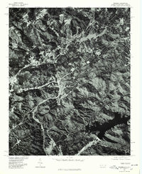 1977 Zirconia1979 Print · USGSThe mountain borderlands of Henderson County appear in sharp relief during the late seventies. Researchers can trace the sprawling shorelines of Lake Summit and the Poinsett Reservoir to study regional water history and land use.
 - 1979 Map of Abbeville, 1980 Print
 1979 Abbeville1980 Print · USGSThe South Carolina and Georgia borderlands are captured here during a period of significant hydroelectric development and regional growth. Researchers can trace the rail-and-river economy through the Seaboard Coast Line and landmarks like Hartwell Dam or the Silk Mills.2 unique versions available
End of results
Showing maps 1-3 of 3
Top cities of Greenville County
- Greenville historical maps
- Mauldin historical maps
- Simpsonville historical maps
- Wade Hampton historical maps
- Travelers Rest historical maps
- Tigerville historical maps
Frequently asked questions
- What are the different types of historical maps available for Greenville County?
- What is the oldest map of Greenville County?
- Where can I purchase historical maps of Greenville County for my home or office?
- Where can I download high-res historical maps of Greenville County?
- Are there historical topographic maps available for Greenville County?
- Is there historical aerial imagery available for Greenville County?
- Where are historical maps of Greenville County sourced from?