1900s (20th Century) Maps of Cross Hill, South Carolina
Explore 11 historic maps of Cross Hill from the 1900s (20th Century). These maps offer a rare glimpse into what life looked like during the 1900s — showing old roads, neighborhoods, homes, and landmarks that have changed or disappeared over time.
Whether you're researching your family's past, planning a metal detecting trip, or studying how Cross Hill's landscape evolved across the 1900s, these high-resolution maps are a powerful tool for exploring the history of this region.
- Focus on a specific era: All maps on this page are from the 1900s, giving you a focused view of this time period.
- See what’s changed: Compare century-old streets, trails, and buildings to today's modern landscape using overlays and satellite layers.
- Research with precision: Use these maps for genealogy, historical research, land use analysis, or educational projects.
- View, download, or print: Maps are fully viewable online in high resolution, and can be downloaded or printed for your own records.
Start exploring Cross Hill's history through authentic maps from the 1900s. This is your window into the past.
Cross Hill, SC maps
(11)- 1941 Map of Spartanburg
 1941 Spartanburg1941 Print · USGSSouth Carolina’s Piedmont and Sandhills regions are shown here during the mid-century peak of the rail era. Researchers can trace the sprawling Fort Jackson Military Reservation and the industrial growth of hubs like Spartanburg and Rock Hill.
 - 1953 Map of Spartanburg, 1966 Print
 1953 Spartanburg1966 Print · USGSMid-century South Carolina comes into focus through this survey of the Piedmont and the Sand Hills at a time of significant reservoir expansion. Researchers can trace the legacy of industrial transit and resource extraction from the Haile Gold Mine to the rail hubs of the Seaboard Air Line.4 unique versions available
 - 1954 Map of Greenville, 1965 Print
 1954 Greenville1965 Print · USGSThe Upstate and Northeast Georgia are captured here during a decade of massive transformation as new reservoirs reshaped the Piedmont. Genealogists and hikers can trace the Appalachian Trail over Brasstown Bald or locate old community centers like Demorest, Westminster, and Royston.3 unique versions available
 - 1958 Map of Greenville
 1958 Greenville1958 Print · USGSThe Piedmont and Blue Ridge foothills come alive in this mid-century survey of the Upstate and Northeast Georgia. Trace the regional rail-and-river economy through the Southern Railway corridors and early reservoir developments like Lake Sidney Lanier.
 - 1960 Map of Spartanburg
 1960 Spartanburg1960 Print · USGSThe South Carolina Piedmont and North Carolina borderlands come alive in this mid-century survey of the region between Spartanburg and Columbia. Researchers can trace the Seaboard Air Line railroad and explore landmarks like Anderson Quarry, Lake Murray, and Mount Croghan.2 unique versions available
 - 1963 Map of Spartanburg
 1963 Spartanburg1963 Print · USGSMid-century South Carolina comes alive in this survey, showing the rail-linked corridor between the Upstate and the Midlands. Genealogists can trace family lands near old hubs like Union and Lancaster, or along the banks of the Broad River and Pee Dee River.
 - 1964 Map of Spartanburg
 1964 Spartanburg1964 Print · USGSMid-century South Carolina comes alive in this survey of the Piedmont and Upcountry, stretching from the Blue Ridge foothills to the Sandhills. Genealogists and historians can trace the rail-and-river economy through Monarch Mills, Glenn Springs, and the Southern Railway corridor.
 - 1970 Map of Cross Hill, 1973 Print
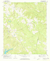 1970 Cross Hill1973 Print · USGSLaurens County in the early seventies shows a landscape where the Seaboard Coast Line railroad and the rising waters of Lake Greenwood meet. Researchers can trace rural lineages through landmarks like Bethabara Ch, Midway Sch, and the old settlement at Milton.
 - 1971 Map of Waterloo, 1975 Print
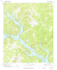 1971 Waterloo1975 Print · USGSThe Laurens and Greenwood County borderlands are defined by the rising waters of Lake Greenwood in the early seventies. Researchers can trace rural church history and rail transport through Waterloo, Cross Hill, and the Seaboard Coast Line corridor.
 - 1979 Map of Abbeville, 1980 Print
 1979 Abbeville1980 Print · USGSThe South Carolina and Georgia borderlands are captured here during a period of significant hydroelectric development and regional growth. Researchers can trace the rail-and-river economy through the Seaboard Coast Line and landmarks like Hartwell Dam or the Silk Mills.2 unique versions available
 - 1986 Map of Newberry
 1986 Newberry1986 Print · USGSSouth Carolina's Piedmont region is shown here in the mid-1980s, revealing a landscape of historic crossroads and industrial mill villages. Researchers can trace family roots through landmarks like Lynch Woods Cem, New Hope Church, and the campus of Presbyterian College.2 unique versions available
End of results
Showing maps 1-11 of 11
Top cities near Cross Hill
- Greenwood historical maps
- Laurens historical maps
- Clinton historical maps
- Ninety Six historical maps
- Joanna historical maps
- Waterloo historical maps
See more
Frequently asked questions
- What are the different types of historical maps available for Cross Hill?
- What is the oldest map of Cross Hill?
- Where can I purchase historical maps of Cross Hill for my home or office?
- Where can I download high-res historical maps of Cross Hill?
- Are there historical topographic maps available for Cross Hill?
- Is there historical aerial imagery available for Cross Hill?
- Where are historical maps of Cross Hill sourced from?