1970s Maps of Newberry County, South Carolina
Explore 12 historic maps of Newberry County from the 1970s. These maps offer a rare glimpse into what life looked like during the 1970s — showing old roads, neighborhoods, homes, and landmarks that have changed or disappeared over time.
Whether you're researching your family's past, planning a metal detecting trip, or studying how Newberry County's landscape evolved across the 1970s, these high-resolution maps are a powerful tool for exploring the history of this region.
- Focus on a specific era: All maps on this page are from the 1970s, giving you a focused view of this time period.
- See what’s changed: Compare century-old streets, trails, and buildings to today's modern landscape using overlays and satellite layers.
- Research with precision: Use these maps for genealogy, historical research, land use analysis, or educational projects.
- View, download, or print: Maps are fully viewable online in high resolution, and can be downloaded or printed for your own records.
Start exploring Newberry County's history through authentic maps from the 1970s. This is your window into the past.
Newberry County, SC maps
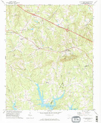
(12)- 1970 Map of Prosperity, 1973 Print
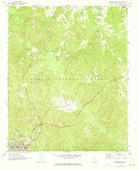
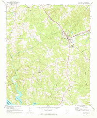 1970 Prosperity1973 Print · USGSNewberry County was a bustling rail and agricultural hub in the early 1970s, centered on the junction at Prosperity. You can trace rural landmarks from the Rikard Sch to numerous historic congregations like St Lukes Ch and Lever Chapel.
 - 1970 Map of Bush River, 1973 Print
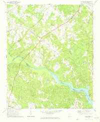
 1970 Bush River1973 Print · USGSThe rural Piedmont of Newberry and Laurens Counties is captured here in the early seventies, just as modern forestry and agriculture shaped the landscape. Researchers can locate family landmarks like the Little River Ch, the Bush River School, and the Silverstreet Lookout Tower.2 unique versions available
 - 1970 Map of Cross Hill, 1973 Print
 1970 Cross Hill1973 Print · USGSLaurens County in the early seventies shows a landscape where the Seaboard Coast Line railroad and the rising waters of Lake Greenwood meet. Researchers can trace rural lineages through landmarks like Bethabara Ch, Midway Sch, and the old settlement at Milton.
 - 1970 Map of Delmar, 1973 Print
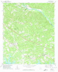
 1970 Delmar1973 Print · USGSSaluda and Newberry Counties center on the expansive shoreline of the Saluda River Lake Murray reservoir in the early seventies. Genealogists and local historians can trace family locations near landmarks like Delmar, Utopia Sch, and the St Marks Ch churchyard.
 - 1970 Map of Whitmire North, 1973 Print
 1970 Whitmire North1973 Print · USGSUnion County during the early 1970s shows a landscape of deep forests and river valleys shaped by the Tyger River. Researchers can trace the legacy of rural communities through sites like Goshen Hill, the Carlisle-Santuc Sch, and several remote family cemeteries.
 - 1971 Map of Joanna, 1973 Print
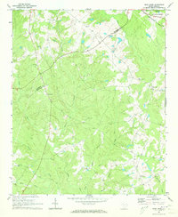
 1971 Joanna1973 Print · USGSThe Laurens County countryside in the early seventies shows the intersection of textile mill culture and institutional growth. Genealogists and local historians can locate several rural landmarks including Hopewell Ch, Bethlehem Ch Cem, and the Whitten Village State Training School.
 - 1971 Map of Chappells, 1973 Print
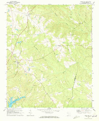
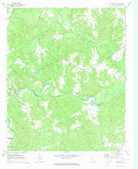 1971 Chappells1973 Print · USGSThe Saluda River valley in the early seventies remains a landscape of quiet rural communities and traditional river-and-rail geography. Genealogists can trace family roots through several country churches like Mt Nebo Ch and Crossroads Ch.
 - 1971 Map of Dyson, 1973 Print
 1971 Dyson1973 Print · USGSThe Piedmont landscape of the early seventies is dominated by the broad reaches of Lake Greenwood and the rural communities of the South Carolina backcountry. You can trace early church locations like Enoree Zion Ch and Salem Ch, or follow the Southern rail line through Dyson.
 - 1971 Map of Silverstreet, 1973 Print
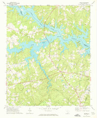
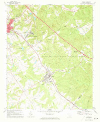
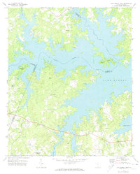
 1971 Silverstreet1973 Print · USGSSilverstreet and the Saluda River valley are captured in the early seventies as Lake Murray reaches into Newberry County. Researchers can trace rural life through landmarks like Welch Zion Ch, Reuben Sch, and the historical crossing at Wateree Ferry.
 - 1971 Map of Lake Murray West, 1974 Print
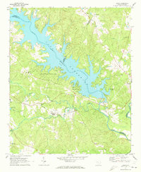
 1971 Lake Murray West1974 Print · USGSThe intricate shoreline of South Carolina's largest reservoir is captured here in the early 1970s. Researchers can trace rural lineages through local landmarks like Red Star, Macedonia Ch, and the community at Ridge Road Crossroads.
 - 1971 Map of Little Mountain, 1974 Print
 1971 Little Mountain1974 Print · USGSThe Newberry and Lexington County border comes into focus in the early 1970s, as the northern reaches of Lake Murray meet the landmark peak of Little Mountain. Genealogists and local historians can trace rural communities like Slighs and Jollystreet, alongside numerous country churches including Mt Tabor Ch and St Peters Ch.2 unique versions available
 - 1971 Map of Chapin, 1974 Print
 1971 Chapin1974 Print · USGSChapin and the northern shores of Lake Murray are shown here in the early 1970s as the area balanced its rural rail history with new shoreline growth. Genealogists can locate family landmarks like Eargle Cem, St Jacobs Ch, and the old settlement at White Rock.3 unique versions available
End of results
Showing maps 1-12 of 12
Top cities of Newberry County
- Newberry historical maps
- Whitmire historical maps
- Prosperity historical maps
- Helena historical maps
- Little Mountain historical maps
- Silverstreet historical maps
See more
Frequently asked questions
- What are the different types of historical maps available for Newberry County?
- What is the oldest map of Newberry County?
- Where can I purchase historical maps of Newberry County for my home or office?
- Where can I download high-res historical maps of Newberry County?
- Are there historical topographic maps available for Newberry County?
- Is there historical aerial imagery available for Newberry County?
- Where are historical maps of Newberry County sourced from?