1970s Maps of Slighs, South Carolina
Explore 1 historic maps of Slighs from the 1970s. These maps offer a rare glimpse into what life looked like during the 1970s — showing old roads, neighborhoods, homes, and landmarks that have changed or disappeared over time.
Whether you're researching your family's past, planning a metal detecting trip, or studying how Slighs's landscape evolved across the 1970s, these high-resolution maps are a powerful tool for exploring the history of this region.
- Focus on a specific era: All maps on this page are from the 1970s, giving you a focused view of this time period.
- See what’s changed: Compare century-old streets, trails, and buildings to today's modern landscape using overlays and satellite layers.
- Research with precision: Use these maps for genealogy, historical research, land use analysis, or educational projects.
- View, download, or print: Maps are fully viewable online in high resolution, and can be downloaded or printed for your own records.
Start exploring Slighs's history through authentic maps from the 1970s. This is your window into the past.
Slighs, SC maps
(1)- 1971 Map of Little Mountain, 1974 Print
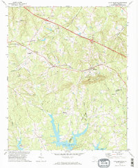 1971 Little Mountain1974 Print · USGSThe Newberry and Lexington County border comes into focus in the early 1970s, as the northern reaches of Lake Murray meet the landmark peak of Little Mountain. Genealogists and local historians can trace rural communities like Slighs and Jollystreet, alongside numerous country churches including Mt Tabor Ch and St Peters Ch.2 unique versions available
End of results
Showing maps 1-1 of 1
Top cities near Slighs
- Lexington historical maps
- Newberry historical maps
- Prosperity historical maps
- Helena historical maps
- Chapin historical maps
- Little Mountain historical maps
See more
Frequently asked questions
- What are the different types of historical maps available for Slighs?
- What is the oldest map of Slighs?
- Where can I purchase historical maps of Slighs for my home or office?
- Where can I download high-res historical maps of Slighs?
- Are there historical topographic maps available for Slighs?
- Is there historical aerial imagery available for Slighs?
- Where are historical maps of Slighs sourced from?