1980s Maps of Rowesville, South Carolina
Explore 3 historic maps of Rowesville from the 1980s. These maps offer a rare glimpse into what life looked like during the 1980s — showing old roads, neighborhoods, homes, and landmarks that have changed or disappeared over time.
Whether you're researching your family's past, planning a metal detecting trip, or studying how Rowesville's landscape evolved across the 1980s, these high-resolution maps are a powerful tool for exploring the history of this region.
- Focus on a specific era: All maps on this page are from the 1980s, giving you a focused view of this time period.
- See what’s changed: Compare century-old streets, trails, and buildings to today's modern landscape using overlays and satellite layers.
- Research with precision: Use these maps for genealogy, historical research, land use analysis, or educational projects.
- View, download, or print: Maps are fully viewable online in high resolution, and can be downloaded or printed for your own records.
Start exploring Rowesville's history through authentic maps from the 1980s. This is your window into the past.
Rowesville, SC maps
(3)- 1982 Map of Orangeburg South
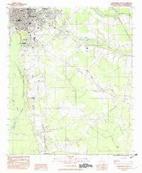 1982 Orangeburg South1982 Print · USGSThe city of Orangeburg and its southern reaches come into focus in the early eighties, showing a landscape defined by education and rail. Researchers can trace the grounds of Claflin College, locate family sites at Sunnyside Cem, or follow the path of the Southern railroad down to Rowesville.2 unique versions available
 - 1982 Map of Branchville North, 1983 Print
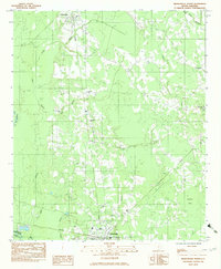 1982 Branchville North1983 Print · USGSThe rural stretches of Orangeburg County are captured here in the early eighties, centered on the railroad corridor between Rowesville and Branchville. Genealogists can locate several family and church landmarks like Peter Bowman Cem, Byrd Cem, and Cattle Creek Ch.
 - 1985 Map of Saint George, 1986 Print
 1985 Saint George1986 Print · USGSThe South Carolina Lowcountry in the mid-eighties shows a landscape defined by the great reservoirs and the meandering Edisto River. Researchers can trace the rail corridors of the Southern Railway and find rural settlements like Harleyville, Smoaks, and Grover.
End of results
Showing maps 1-3 of 3
Top cities near Rowesville
- Orangeburg historical maps
- Bamberg historical maps
- Bowman historical maps
- Branchville historical maps
- Cameron historical maps
- Reevesville historical maps
See more
Frequently asked questions
- What are the different types of historical maps available for Rowesville?
- What is the oldest map of Rowesville?
- Where can I purchase historical maps of Rowesville for my home or office?
- Where can I download high-res historical maps of Rowesville?
- Are there historical topographic maps available for Rowesville?
- Is there historical aerial imagery available for Rowesville?
- Where are historical maps of Rowesville sourced from?