1920s Maps of Santee, South Carolina
Explore 4 historic maps of Santee from the 1920s. These maps offer a rare glimpse into what life looked like during the 1920s — showing old roads, neighborhoods, homes, and landmarks that have changed or disappeared over time.
Whether you're researching your family's past, planning a metal detecting trip, or studying how Santee's landscape evolved across the 1920s, these high-resolution maps are a powerful tool for exploring the history of this region.
- Focus on a specific era: All maps on this page are from the 1920s, giving you a focused view of this time period.
- See what’s changed: Compare century-old streets, trails, and buildings to today's modern landscape using overlays and satellite layers.
- Research with precision: Use these maps for genealogy, historical research, land use analysis, or educational projects.
- View, download, or print: Maps are fully viewable online in high resolution, and can be downloaded or printed for your own records.
Start exploring Santee's history through authentic maps from the 1920s. This is your window into the past.
Santee, SC maps
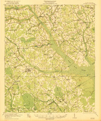
(4)- 1920 Map of Eutawville
 1920 Eutawville1920 Print · USGSCoastal South Carolina comes to life in the years following the Great War, showing a landscape defined by the Santee River and Four Hole Swamp. Genealogists can trace family roots through numerous local landmarks like Black Creek Church, Unity School, and the settlement at Holly Hill.
 - 1920 Map of Bowman
 1920 Bowman1920 Print · USGSIn the early twentieth century, this part of the South Carolina Lowcountry was a landscape of remote settlements and small-scale industry. Genealogists can trace family footprints through numerous community landmarks like Boghette Cem, Livingston Mill, and the Shady Grove Camp Ground.
 - 1921 Map of Bowman
 1921 Bowman1921 Print · USGSIn the early 1920s, the rural community of Bowman was a bustling intersection of country schools and swamp-fed drainage. Genealogists can trace family footprints through dozens of landmarks like Rochette Cemetery, the Campmeeting Grounds, and Livingston Mill.4 unique versions available
 - 1921 Map of Eutawville
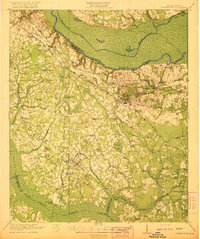 1921 Eutawville1921 Print · USGSCoastal South Carolina comes to life in this early twentieth-century survey of the Santee River lowlands and the growing railroad towns of the coastal plain. Genealogists can trace the location of community anchors like Gerizim Church, the Eutaw Springs Battle Monument, and Nelsons Ferry.3 unique versions available
End of results
Showing maps 1-4 of 4
Top cities near Santee
- Holly Hill historical maps
- Bowman historical maps
- Summerton historical maps
- Elloree historical maps
- Cameron historical maps
- Eutawville historical maps
See more
Frequently asked questions
- What are the different types of historical maps available for Santee?
- What is the oldest map of Santee?
- Where can I purchase historical maps of Santee for my home or office?
- Where can I download high-res historical maps of Santee?
- Are there historical topographic maps available for Santee?
- Is there historical aerial imagery available for Santee?
- Where are historical maps of Santee sourced from?